| | |
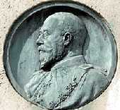 |
King Edward VII. |
In King Edward VII Gardens just off The Highway. Edward was Prince of Wales for 60 years due to the longevity of his mother, Queen Victoria; but was King for only 9 years (1901-1910). The Highway, formerly known as Ratcliffe Highway, was so called because it was originally the ancient road built on a causeway that passed through the marshy areas beside the Thames.
(See No. 1. on Map )
Sculptor: B. MacKennal. Date: 1922.
|
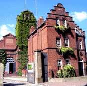 |
London Hydraulic Power Company. |
Wapping Wall, almost opposite the Prospect of Whitby. This building, dated 1890, was one of a number that pumped water in underground pressure tubing to provide hydraulic power to work the cranes, capstans, bridges and lock gates in the docks. The tall ivy-covered tower in the photo was the "accumulator". As the water filled the tower it raised a weighted plunger usually filled with gravel, which built up pressure at the base to about 700 pounds per square inch. The pumps used to fill the tower were driven by steam engines. It was called an accumulator because water was pumped in during off-peak times and was stored to provide power in busy periods. Hydraulic power was first introduced into the docks in 1852 by William Armstrong of Newcastle. This was the last building to provide hydraulic power and finally shut down operations in 1977. The building with the open door is now the Wapping Project Gallery and puts on exhibitions. Anyone who visits the exhibitions or the caf� will see the pumping machinery still housed there. Several of these "accumulator" towers are still standing. A derelict one is next to the DLR station at Tower Gateway and another is visible beside the track in Limehouse. (See No. 2. on Map )
Examples of devices that were driven by hydraulic power and which can still be seen are Tower Bridge, Shadwell Bridge, Millwall Lock and Hydraulic Hoist
 Hydraulic Power. Hydraulic Power.
|
 |
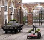
Mobile Flowerpots,
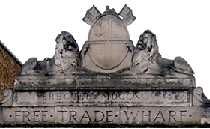
East India Wharf & The Ratcliff Fire. |
Just off The Highway, next to the Scotia building and now called Atlantic Wharf. The base of a railway goods wagon and one of the hand-propelled little buggies used by railway maintenance staff, stand on rail track and are now used for stands for flower pots.
At the end of this courtyard, behind where the upper photograph was taken, there is an archway dating from 1846. On it is written FREE TRADE WHARF, an earlier name for the area. On top of this arch are the arms of the East India Company who were even earlier owners of the wharf and whose warehouses were destroyed in a fire.. This area was known as Ratcliff(e). In July 1794, a disastrous fire broke out here, when a kettle of pitch in Clove's barge builders yard boiled over, and the resulting fire ignited a barge loaded with saltpetre. This set off a series of explosions sending burning saltpetre over a wide area. This fire completely destroyed 453 private houses, more than 20 warehouses or large buildings and several ships on the Thames. 150 tents were set up to house about 1000 of the homeless in Stepney Fields by St Dunstan's Church. It was the worst fire disaster in London between the Great Fire of 1666 and the Blitz of 1940. (See No. 3. on Map)
|
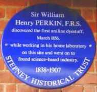 |
Sir William Henry Perkin. |
On the wall of Gosling House at the junction of Cable Street and King David Lane. William Henry Perkin (1838-1907) lived here and was a student of chemistry. At the age of 17, he was trying to make quinine synthetically to be used as a cure for malaria in the laboratory in his home on this site. One of his unsuccessful attempts produced a brilliant mauve liquid dye. He quickly realised its potential, for he had discovered the world's first aniline dye. He discovered other colours and went on to manufacture them on a large scale. He therefore started the modern chemical industry of producing synthetic dyes. It is thought that his mauveine was used in the printing of the penny lilac stamp of Queen Victoria. If left wing political plaques could be coloured red, then it does seem a pity that this plaque was not made in mauve. (See No. 4. on Map)
The Chemistry of Mauveine.
Perkin's Mauve.
|
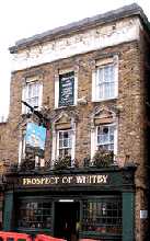 |
Prospect of Whitby. |
Wapping Wall. Like many of those seaside guesthouses called "Sea View", the title of this famous pub should not be taken literally. Whitby is approximately 230 miles to the north. The pub is, therefore, thought to have been named after a ship that was moored nearby. The rear of the pub has a magnificent view over the Thames. And there is also a hangman's noose to attract law-abiding customers. (See No. 5. on Map)
Prospect of Whitby
|
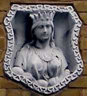 |
Queen Agnes. |
Belgrave Street, just off the Commercial Road on the side of the Renauld Dealers showroom and repairs. This old carving of a crowned female head looks older than the brick wall in which it is now set. As the whole of this area originally belonged to the Mercers' Company and their symbol was "Queen Agnes", it seems probable that this came from an earlier building on this site. It was a common practice for the Mercers' Company to mark their properties in this way. See Mercers Cottages for more about Queen Agnes . (See No. 6. on Map)
|
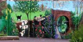 |
St Mary and St Michael School. |
Sutton Street. This shows a detail from a long mural that runs along the side of the school playground and can be seen through the railings from the pavement outside. (See No. 7. on Map)
|
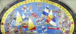 |
Shadwell Basin Project. |
By Shadwell Dock Stairs. Design in ceramic tiles on the front of the building, showing the activities run by the project, and commemorating the opening by Prince Charles. (See No. 8. on Map)
Date: 1987.
Shadwell Basin Project
|
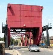 |
Shadwell Bridge. |
Between Wapping Wall and Glamis Road. This bridge used to swing upwards to let ships enter Shadwell Docks. The hydraulic power to raise this heavy bridge was provided by the nearby London Hydraulic Power Company. It may seem surprising that such a large bridge could be moved by water power. But it was not the only one. Tower Bridge still raises and lowers the roadway sections using hydraulic power. For a brief explanation of the method see the London Hydraulic Power Company. The large mauve metal structure at the near end of the bridge in the photo is a tank that filled with water to provide the counter-balance weight for the roadway.
Wapping Wall like Blackwall was originally a flood wall to prevent the Thames flooding the surrounding area of low ground. (See No. 9. on Map )
|
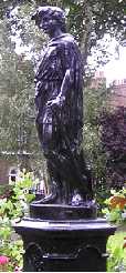 |
"Shepherd Boy" Fountain. |
Albert Gardens, off Commercial Road, in the central gardens. Although listed in at least one official list as the Shepherd Boy Fountain, this is a misnomer. Firstly, it is no longer a working fountain and is now just a statue. Secondly, the figure is not a shepherd. He is holding a sickle and leaning against a sheaf of corn and would be more appropriately named "Young Harvester". The statue is marked "DFR" and was made in Paris by Fonderies d'art du Val D'Orne in 1903. The surrounding houses, formerly called Albert Square, date from the first part of the 19th century. The name was changed in 1938, which was well before the TV programme "Eastenders" began. (See No. 10. on Map)
Date: 1903.
|
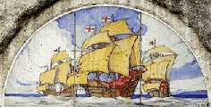 |
The Willoughby Memorial. |
In the King Edward VII Park, Shadwell on the side of the Rotherhythe Tunnel Air Shaft 3. This depiction of sailing ships is on ceramic tiles. The inscription under it says that it was erected in memory of "�navigators who in the latter half of the sixteenth century set sail from this reach of the River Thames near Ratcliffe Cross." (Ratcliffe Stairs at the end of Narrow Street) Four of these men are mentioned by name:
- Sir Hugh Willoughby. He led an expedition in 1553 to discover unknown regions and reached Russian Lapland, where he and his crew died.
- Stephen Borough. He reached Russia with the same expedition and returned safely.
- William Borough. In 1587, he sailed with Drake to Cadiz to "singe the King of Spain's beard." In 1588, he commanded one of the ships that defeated the Spanish Armada.
- Sir Martin Frobisher. In 1576, while searching for the North-west passage, he reached Labrador and discovered what is now Frobisher Bay. He brought back with him 200 tons of iron pyrites (fool's gold) thinking that because it shone like gold it must contain gold, but was sadly disappointed. In 1585 he sailed with Drake to the West Indies and in 1588 he helped to defeat the Armada.
(See No. 11. on Map)
Signed: Carter Poole. 1922.
Martin Frobisher
|
 TO READ NAME ~ CLICK FOR PHOTO & EXPLANATION.