BECKTON, E 6.
PUT MOUSE OVER  TO READ NAME ~ CLICK FOR PHOTO & EXPLANATION.
CONTENTS |
||
| 1. BECKTON ALPS. | 2. BECKTON'S OLD HOUSES. | 3. "BIRDS". |
| 4. COOKERY CENTRE. | 5. GALLIONS REACH POLE. | 6. GALLIONS WAY PRIMARY SCHOOL. |
| 7. THE GAS WORKS. | 8. "GROW TOGETHER". | 9. GYMNASTICS. |
| 10. "HORSES". | 11. NURSERY RHYMES. | 12. ANONYMOUS OBELISK. |
| 13. MOSAIC SEATS. | 14. ST. MARY MAGDALENE. | 15. MULTICOLOURED SIGNPOST. |
| 16. "SKYLARKS AND HOMES." | 17. THE WELL. | |
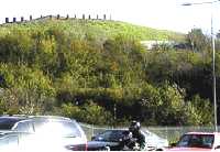 |
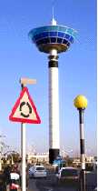
"The Beckton Alps." |
|
At the junction of Newham Way with Woolwich Manor Way. As Beckton is built on a low-lying flood plain, this is its highest point. It is not natural as it was made when the Gas works dumped the waste products of their manufacturing processes here. For a short time it was used as a practice ski run and so it was often called "the Beckton Alps". (See No. 1. on Map) |
||
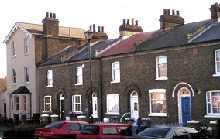 |
Beckton's Old Houses |
|
Winsor Terrace. In 1870 the Gas, Light & Coke Company began producing gas here. The coal arrived by boat and was unloaded at the firm's jetties along the Thames and at Barking Creek. Winsor Terrace and Tollgate road were originally the firm's own private road for their own use. The name Winsor comes from Freidrich Winzer who founded the company in 1812. By 1870, the head of the company was Simon Beck, who installed the firm's railway system and built houses for his employees. That is why the area is called Beckton. (See No. 2. on Map) |
||
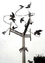 |
"Birds." |
|
Beckton Park on the eastern half of the main East-west path. Beneath the birds are the two mosaic-decorated seats, also with the theme of nature. (See No. 3. on Map) Sculptor: Brian Yale. (See also "Horses" and "The Port of London" by the same artist.) |
||
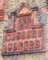 |
The Cookery Centre. |
|
Vicarage Primary School, Vicarage Lane. The school started in 1901, but these buildings were erected in 1911. At that time girls and boys were educated separately and this building was put up so that girls could learn how to be good housewives. The photo shows that above the building's name there is the coat of arms of East Ham. A clearer photo of these arms is on the town Hall. (See No. 4. on Map) |
||
 |
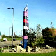
Gallions Reach Pole. |
|
This tall structure in the middle of Gallions Reach Shopping Park is like a giant totem pole with cars and their occupants dancing around in worship. This feature is a landmark which is visible from a large distance. (See No. 5. on Map) |
||
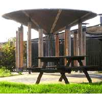 |
Gallion's Way Primary School. |
|
Off Oxleas. This interestingly shaped structure can be seen from the path at the rear of the building together with a smaller sculpture. (See No. 6. on Map) |
||
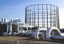 |
The Gas Works. |
|
Gallions Reach. For many years Beckton was little more than a large gasworks. It was the largest gas producing plant in Europe. From the coal they produced gas, but there were also important by-products like coke, dyes, fertilizers, etc. Then came a switch from coal gas to natural gas. This led to a dramatic drop in production, but some of the original installation can still be seen, as shown in this photo (2006). The gasometer, the cylindrical framework at the back, held an expandable container which stored the gas produced, which could then be used to satisfy the demand at peak periods. (See No. 7. on Map) |
||
 |
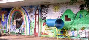
"Grow Together." |
|
One of three murals on the front of Ellen Wilkinson Primary School, Tollgate Road. The school's motto is "Learning to grow and succeed together." So the other two are "Learn Together" and "Succeed Together." In 1945, Ellen Wilkinson became the first woman to be made Minister of Education. (See No. 8. on Map) |
||
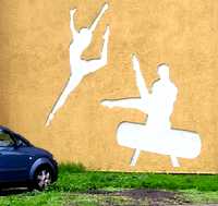 |
Gymnastics. |
|
At the junction of Triumph Road and Frobisher Road. These designs are two of the silhouette pictures on the walls of Gymnova, East London Gymnastics Club. The designs appear to be pressed into the wall surface. (See No. 9. on Map) |
||
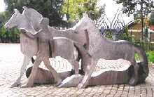 |
"Horses." |
|
At the entrance to Beckton park opposite to Beckton DLR station and not far from the Asda supermarket. This group is made in stainless steel. It stands in a circle partly surrounded by an attractive screen of trees by the same artist. A section of the screen is just visible in the background of the photo. (See No. 10. on Map) Sculptor: Brian Yale. (See also "The Port of London" and "Birds" by the same artist) |
||
 |
Nursery Rhymes. |
|
North Beckton Primary School, Harrier way. The mural is displayed in the playground. Among the nursery rhymes illustrated are: "Hey Diddle Diddle", "Hickory Dickory Dock", "Little Miss Muffet", "Jack and Jill" and "One Two Buckle My Shoe". In this collage there are two or three more, which are more difficult to make out. (See No. 11. on Map) |
||
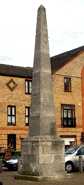 |
The Anonymous Obelisk. |
|
Tollgate Road, between Swallow Street and Kingfisher Street set back behind the green. This is one of two such obelisks which have been erected, but which seem not to commemorate anything and are just for show. The other is in an enclosed green square between Ambassador Gardens and Concorde Drive. (See No. 12. on Map) |
||
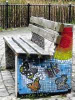 |
Mosaic Seats. |
|
In Beckton Park on the eastern half of the main East-west path. The photo shows butterflies and is one of four different mosaic designs on two seats, each with a nature theme. These benches have the "Birds" flying overhead. (See No. 13. on Map) |
||
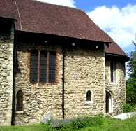 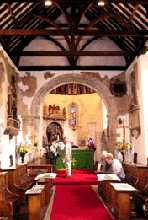 |
St Mary Magdalene. |
|
The parish church of East Ham dates back to the 12th century and retains more of its original Norman features than any other in London. The surrounding churchyard has been turned into a nature reserve, so that it is easy to see the exterior. |
||
 |
Multicoloured Signpost. |
|
Armada Way close to the junction with Royal Docks Road. This pillar, which was intended as a signpost to advertise the retail outlets in Gallions Reach Shopping Park, and has been landscaped to make it eye-catching. (See No. 15. on Map) |
||
 |
"Skylarks and Homes." |
|
On the wall of 196 Tollgate Road and visible from Bradley Stone Road. The birds are flying round a circle of houses. The sculptor was assisted by 16 young people. The birds are skylarks which once were more commonly seen in the area. For the origin of the name of the road see the story of Bradley Stone. (See No. 16. on Map) Artist Coordinating project: Kevin McKeon. Date 1996. |
||
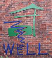 |
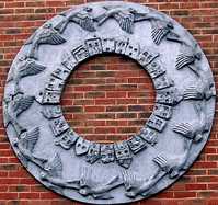
The Well. |
|
49 Vicarage Lane, East Ham. This interesting logo is outside the door of the building, which is a community centre for those living in the Vicarage Lane area. (See No. 17. on Map) |
||
OTHER AREAS COVERED:-
|| Bethnal Green || Blackwall || Bow || Bromley-by-Bow || Canary Wharf || Canning Town || Chingford || Cubit Town || Custom House || East Ham || East India Dock || Forest Gate || Higham's Park || Leyton || Leytonstone || Limehouse || Little Ilford || Manor Park || Mile End || Millwall || North Woolwich || Plaistow || Plashet || Poplar || St George's || St Katharine Dock || Shadwell || Shoreditch || Silvertown || Snaresbrook || Spitalfields || Stepney || Stratford || Upton || Walthamstow East || Walthamstow Village || Walthamstow West || Wanstead || Wapping || West India Dock || Whitechapel || Woodford || |