SHOREDITCH.
| The name Shoreditch is thought to have been derived from a small brook called the Soer which flowed through here and emptied into the Thames. In the late middle ages, this area, being just outside the city walls, was thought to be rather seedy. The earliest of theatres in London were built here and the area was notorious for other houses of ill repute. |
PUT MOUSE OVER  TO READ NAME ~ CLICK FOR PHOTO & EXPLANATION.
CONTENTS | |
| 1. 118Ẅ SHOREDITCH HIGH ST. | |
| 2. BAND STAND | |
| 3. BATH HOUSE | |
| 4. THE CROWN & SHUTTLE | |
| 5. FIREMEN & BODY-SNATCHERS | |
| 6. GARDENERS' MURAL | |
| 7. SIR ROBERT GEFFRYE | |
| 8. GEFFRYE MUSEUM | |
| 9. GOODS YARD GATEPOST | |
| 10. GRAFFITI | |
| 11. HUGUENOT STREET NAME | |
| 12. LABOURER | |
| 13. "THE LESSON" | |
| 14. "LONDON MOSAIC" | |
| 15. THE PARISH PUMP ? | |
| 16. QUEEN ADELAIDE | |
| 17. "THE QUEEN VIC" | |
| 18. "RAILWAY SCULPTURES" | |
| 19. ST LEONARD'S CHURCH. | |
| 20. "ST MATTHEW'S CHURCH" | |
| 21. STREET SIGNS. | |
| 22. THE TELEPHONE MAN. | |
| 23. THE THEATRE. | |
| 24. "THREADS". | |
| 25. "UNTO THIS LAST" |
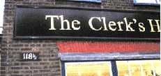 |
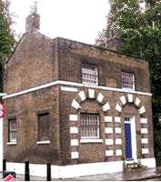
118Ẅ Shoreditch High Street. |
|
The Clerk's House, No. 118Ẅ Shoreditch High Street. As its name implies this house was originally occupied by clerics from St Leonard's Church, next door. It is now occupied by a Ladies wear shop. Before the current practice of adding letters to house numbers when an extra house was built in a street, it was common to add a half. (See No. 1. on Map) Date: 1735. | ||
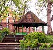 |
The Bandstand. |
|
On the large central island of Arnold Circus. This marks the central focal point of the Boundary estate which was built in the 1890s to replace an area of slum housing. The once grand bandstand is now damaged and it looks doubtful that any band has played here for several years. (See No. 2. on Map) | ||
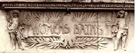 |
The Bath House |
|
At the corner of Ramsey Road and Dunbridge St. This bath house was erected in 1899 at a time when almost none of the houses or flats in the area had a bath. And now times have changed completely and all houses have running water. Public baths are redundant. And this bath house has been converted into apartments. The photo shows the women's entrance, there was a separate entrance for men. (See No. 3. on Map) | ||
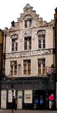 |
Crown and Shuttle. |
|
226 Shoreditch High Street. This pub, the Crown and Shuttle, which is now (2006) closed and boarded up, still bears a name linked to the Huguenot weavers of Spitalfields. Almost opposite to it, just over the bridge, is a narrow lane called Fleur de Lis Street, which is another reminder of these French immigrants. (See No. 4. on Map) | ||
 |
Firemen and Body-snatchers. |
|
On the corner of St Matthews Row and Wood Close and named on the front door as "The Watch House". This building began as a watchman's house in 1754. The watchman was to guard against "the resurrection men" or body-snatchers who provided corpses for dissection to the local hospitals. In 1826 the building was enlarged so that the fire engine could be housed here. In recent years it has been used by the church for many other functions. (See No. 5. on Map) |
||
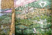 |
Gardeners' Mural. |
|
A section of the mural on the side wall of 199 Kingsland Road. This mural is partly painted and partly mosaic with some mirror tiles included. It shows the cultivation of fields of vegetables and other plants. Today this seems a little out of place. However, a map of 1840 shows that about 50 yards to the north on the other side of Kingsland Road there was then a large market gardener and plant nursery which covered a big area. (See No. 6. on Map) |
||
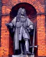 | Sir Robert Geffrye. |
|
Over the main entrance of the Geffrye Museum, Kingsland Road. The building was erected in the 18th century as alms houses run by the Ironmongers' Company. Under the sculpture it is written Geffrye was "Alderman and Ironmonger and founder of this Hospitall". The building was not a medical hospital, but it did provide hospitality to the poor. (See No. 7. on Map) |
||
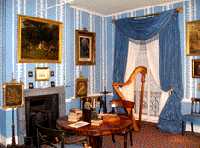 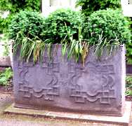 |
Geffrye Museum. |
|
Kingsland Road. The upper photo shows one of the series of rooms illustrating the furniture and home life of different periods from 1600 to the present day. This photo shows the late Regency period (1800-1820). Modern galleries have been added to illustrate more recent times. The museum is close to Hackney Road which used to be the centre of the furniture and joinery trades. There were many small factories and workshops producing hand made furniture. A few still survive today. Entry to the museum is free. It is closed on Mondays. Behind the museum there is a herb garden which is laid out to illustrate different historical periods of gardening. The area north of the museum was known for its horticulture. This heavy lead planter (lower picture) is in front of the museum and is dated 1761, which places it before both the French and American Revolutions. (See No. 8. on Map) |
||
 |
Goods Yard Gatepost. |
|
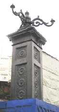
Shoreditch High Street. This was one of the gateposts at the entrance to what was the busy LNER (railway) goods yard. It has been listed and therefore the base was partly covered up to prevent damage while construction work is being carried out on the new rail link but by 2008 the gatepost had disappeared. Let us hope that it will return when the work is completed. (See No. 9. on Map) |
||
 |
Graffiti. |
|
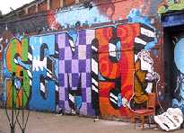
On a wall by a second hand shop in Sclater Street, which is partly under the railway. This is just part of a much larger artistic display which shows considerable skill both in design and in the use of colour. This artwork has now (2008) disappeared as a result of the new railway development, however a number of new graffiti are visible in this area. (See No. 10. on Map) The Artists wish to remain anonymous for legal reasons. 2006. |
||
 |
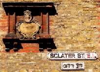
Huguenot Street Name. |
|
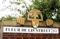
The corner of Fleur de Lis Street and Shoreditch High Street. At this point the street is little more than a passageway. The "sculpture" which has nothing to do with the street name, represents a chad and is semi-permanent, being made of wood and screwed to the wall. The street name is a reminder of the French Calvinist Protestants known as Huguenots many of whom fled to this country following the St Bartholomew's Day Massacre of 1572 and settled round Spitalfields. The fleur de lis is the heraldic device, often used by the French, which is also shown in the background wallpaper of the front page of this web site. For other places in East London connected with Huguenots see (See No. 11. on Map) |
||
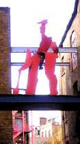 |
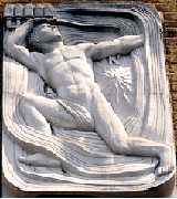
Labourer. |
|
Next to 25 Hackney Road over the entrance to the Preserverance Works. The figure is a metal sculpture which is raised up high on a kind of bridge, forming the entrance to a courtyard which is surrounded by a number of small industrial units. (See No. 12. on Map) |
||
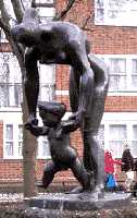 |
"The Lesson" |
|
On the corner of Turin Street and Osset Street, E2. This shows a woman teaching a child to walk. (See No. 13. on Map) Sculptress: Franta Belsky. Date: 1958. (see also "The Leap" by the same artist.) |
||
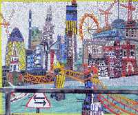 |
London Mosaic |
|
One of two mosaics on the wall of William Davis Primary School, Wood Close. This one features many London landmarks such as Tower Bridge, the Gherkin and the London Eye. It also depicts the Watch House which is almost opposite it. (See No. 14. on Map) |
||
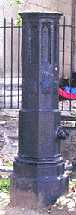 |
The Parish Pump. |
|
In St. Leonard's Churchyard, Shoreditch. The remains of a pump, The handle is missing. In the days before running water was piped into houses, water had to be carried into the house in buckets, usually drawn from a well. This well in the churchyard should not be confused with the Holy well that was not far away. The latter was on the other side of Shoreditch High Street and probably over two hundred yards to the south. This latter well gave rise the name of Holy Well Priory which was situated there, and later by Holywell Lane, which in turn commemorates the priory. (See No. 15. on Map) |
||
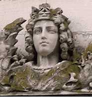 |
Queen Adelaide. |
|
41 45 Pollard Row. This was formerly the Queen Adelaide Dispensary. Queen Adelaide (1792-1849) was the wife of William IV and aunt of Queen Victoria. The first dispensary was built here in 1849 after one of the disastrous Cholera epidemics of the 19th century. The present building replaced it some 20 years later. It has now been converted into private housing. (See No. 16. on Map) | ||
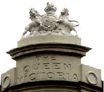 |
The Queen Vic. |
|
On the corner of Wellington Row and Barnet Grove. The royal arms usually signify royal patronage. However, it is very doubtful that the Queen ever visited this pub. The most likely member of the royal patrons at that time would have been the Prince of Wales; but he had another pub named after him which is on the corner opposite. Only the name survives of the latter as there is no coat of arms. Neither building is now a pub. (See No. 17. on Map) |
||
  |
Railway Sculptures. |
|
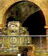
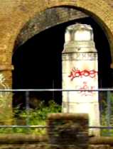
Two of five carved architectural fragments on the south east side of the Stratford to Liverpool Street main line railway as it approaches the terminus. They come originally from the original Liverpool Street Station, built in 1874, where they stood for just over a century. The one shown in the left photo was originally one of three placed high on an exterior wall. Each of these held a single letter and read G E R standing for the Great Eastern Railway, which was it's former name. Interestingly, the easternmost of the five fragments still has the E at its centre. The photo on the right shows one of the pillars, which stood at the top of the slope from Bishopsgate, where the horse-drawn cabs went down to the platforms to pick up or put down passengers and their luggage. Reproductions of both of these can now be seen near the Bishopsgate exit of the station. (see No. 18. on Map) |
||
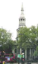 |
St Leonard's Church. |
|
At the junction of Shoreditch High Street and Hackney Road. The present church dates from 1735, but it replaced an earlier one dating back to the thirteenth century. In 1716, the walls of the old church "were rent asunder with a fearful sound during divine service" and the congregation had to make a quick exit. It is one of these churches that is mentioned in the rhyme "Oranges and Lemons" in the line: "When I grow rich said the bells of Shoreditch.". In the Tudor period it was the actors' church. Among those buried in the old burial ground were:
|
||
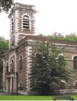 |
St. Matthew's Church. |
|
St Matthew's Row. This church was one of the 50 churches planned to be built in the 18th century to counter non-conformism. Completed in 1746, it was the work of George Dance. Two remarkable and dissimilar characters were associated with it. |
||
 |
Street Signs. |
|
The corner of Sclater Street and Brick Lane. This collection of three street signs illustrates some of the changes which have taken place. The oldest sign has incised into it: "This is Sclater Street 1708" this date was long before London was divided into Postal districts. While the latest one is in Bengali script for recent immigrants. (See No. 21. on Map For an even older street sign see Whitechapel Bell Foundry. ) |
||
 |
The Telephone Man. |
|
Eastern side of Shoreditch High Street. The carving on the front wall shows a figure who seems to be tangled up in a mass of telephone cables. Incidentally, he is breaking current laws because he is not wearing a safety helmet. (See No. 22. on Map) Sculptor: (?) date 1956 ? |
||
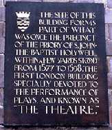 |
The First Theatre. |
|
James Burbage's theatre of 1576, being the first, was simply called "The Theatre" and was situated near St Leonard's Church on a site which is now occupied by 86-88 Curtain Road, EC2, where this plaque is displayed. Shakespeare was an actor in the resident troupe, and Romeo & Juliet and some other of his plays had their first performances here. Eventually, after a dispute over the lease of the site, one night in 1598 the company (including Shakespeare) pulled the theatre down and transported its timbers across the Thames and used them to build "The Globe Theatre". Curtain Road got its name from another theatre called "The Curtain" which was situated close to "The Theatre", or both were named after the curtain wall that surrounded the Holywell Priory, that originally stood on this site. Before these theatres were built, actors were travelling players. These theatres were built outside the city boundaries, because the authorities disapproved of such entertainment. A panoramic view of London c. 1598 shows a tall cylindrical building 3 stories high in this part of London, which would have been too big to dismantle in a night, and so was possibly the Curtain Theatre. In 2008, the brick foundations of "The Theatre" were found below a building in New Inn Broadway. (See No. 23. on Map) |
||
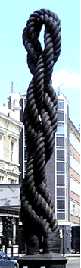 |
"Threads." |
|
Bethnal Green Road, E2, near the junction with Sclater Street. This sculpture was erected as part of the Bethnal Green City Challenge Research Programme. It was made by a brother and sister, who used a century-old rope to make it. It was intended as a reminder of the connection of the area with the garment and textile industries, or with what the local inhabitants used to call "The Rag Trade". Rope making was also carried out in this area. (See No. 24. on Map) Sculptors: Tim and Hattie Coppard. 1996. |
||
 |
"Unto This Last." |
|
Upper end of Brick Lane, north of Bethnal Green Road, on a corner building above the doorway of a furniture warehouse on the corner of Shackewell Street. (See No. 25. on Map) |
||

OTHER AREAS COVERED:-
|| Beckton || Bethnal Green || Blackwall || Bow || Bromley-by-Bow || Canary Wharf || Canning Town || Chingford || Cubit Town || Custom House || East Ham || East India Dock || Forest Gate || Higham's Park || Leyton || Leytonstone || Limehouse || Little Ilford || Manor Park || Mile End || Millwall || North Woolwich || Plaistow || Plashet || Poplar || St George's || St Katharine Dock || Shadwell || Silvertown || Snaresbrook || Spitalfields || Stepney || Stratford || Upton || Walthamstow East || Walthamstow Village || Walthamstow West || Wanstead || Wapping || West India Dock || Whitechapel || Woodford || |