| | |
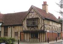 |
Ancient House. |
On the corner of Church Road and Orford Road. This 15th century timber-framed building was allowed to deteriorate and at one time it was used as a bicycle shop, but it was restored in 1934. Beside the bow window (which is a late addition) a section of the old wattle and daub construction of the walls is visible behind glass. Similarly the pavement has been cut away and replaced by glass along the frontage to show the original ground level and to show how much it has risen in nearly six centuries. (See No. 1. on the MAP) |
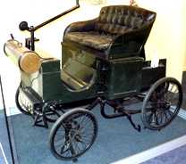 |
The Bremer Car. |
Now on public show in the Vestry House Museum. Frederick Bremer built this car in Walthamstow and took it for a drive in 1892. It was arguably the first petrol-driven car to be used in Britain. (In view of London's present traffic problems, Bremer has a lot to answer for.) The car was little used and has spent most of its life in museums. However, in 1965, after being overhauled and carefully renovated, it was driven to Brighton in the annual Old Crocks run. It covered the 54 miles to Brighton in just under 8 hours. Note it has a tiller handle rather than a steering wheel to change the direction of travel. (See No. 2. on the MAP) For other transport pioneers in East London see The First Bus to Brighton and the First All-British flight of a powered aircraft.
|
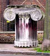 |
Corinthian Capital. |
Vestry Road, outside the Vestry House Museum. This capital originally capped a column which came from the General Post Office, which was pulled down in 1912, and which stood near to St Paul's Cathedral. (See No. 3. on the MAP) |
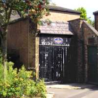 |
The Old Fire Station. |
What looks like a small detached garage in Vestry Road (Opposite the Vestry House Museum) was used for housing the local fire engine. At that time the water pump had no engine, and had to be pushed and pulled around by the firemen. After many years, it was modernised in 1863 so that it could be pulled by horses. A pump of this kind may be seen at the Pump House Museum. (See No. 4. on the MAP) |
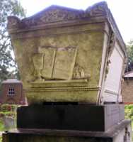 |
The Merchant's Tomb. |
In St Mary's churchyard, visible from the main north-south path. There are a number of large family tombs from the 18th and 19th centuries in which several members of the same family were buried together. These elaborate burial places reflect the wealth of some of the families who lived in this area at that time. This grave of the Dobree family has on the end of it a wine cup, a book and a plate of what looks like large sugar lumps.
From the 15th century onwards, sugar was sold in loaves, often weighing more than a pound. It was then broken into lumps using sugar nippers. Samuel Dobree, who died in 1816, is described as being a "merchant". If these are indeed sugar lumps, then he was probably involved in the slave trade. Because there were many merchants following a triangular trade route taking trinkets from England to Africa, selling them there and picking up slaves to transport to the West Indies and then loading up with sugar for the English home market. On the tomb it states that he was of Old Broad Street in London, but he became rich enough to buy a country house near Walthamstow. (See No. 5. on the MAP) |
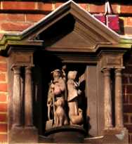 |
Monoux Almshouses. |
In Vinegar Lane, behind St Mary's Church. The sculpture shows a bearded man holding shovel in one hand and a shepherd's crook in the other and has a dog at his feet. The woman has a goose at her feet. The explanatory text below statess:
This Portal was set up in pious
Memory of Sir George Monoux
Who founded these Almshouses
And the school bearing his name
AD 1527 and to commemorate
Their restoration AD 1944 after
Destruction by enemy action
AD 1941 during the second
World War
LAUS DEO
|
| 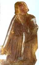
Brass showing George
Monoux in St Mary's
Church, Walthamstow.
|
Laus Deo is the Latin equivalent of the Hebrew word Halleluyah and means Praise be to God!
Sir George Monoux (c.1465 -1544) was Lord Mayor of London in 1514. Vinegar Lane is a very old pathway dating from the mediaeval period and probably got its name from the fact that in St. Mary's churchyard there are two mass graves, one of them was for victims of the Black Death (c. 1347) and the other for those of The Great Plague of 1665. Pits were dug here and filled with vinegar and were thought to prevent the spread of infection. (See No. 6. on the MAP)
|
 |
The Nag's Head. |
Orford Road. This building only dates from 1857, but the pub is much older for The Nag's head moved from the corner of Orford road opposite the Ancient House. It had been there from at least the 16th century. This was a prime site for a pub as it was at the crossroads where the north-south road (Orford Road continuing past the Church door) and the east-west road (Church Lane, Church Passage and St Marys Road). The photo shows the coach house and this has historical links. From about the middle 1700s the owner of the old Nag's Head used to run a stage coach from Walthamstow to Leyton and this continued for at least 20 years of the new building. (See No. 7. on the MAP) |
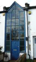 |
Narrowest House. |
Church Passage. The narrowest house in Walthamstow, this is about 2.5 metres wide on the outside. The interior is less. Church passage was in a main road in the middle ages. It was the continuation of Church Lane leading through into what is now St Marys Road. It was therefore the main East-West thoroughfare. (See No. 8. on the MAP) |
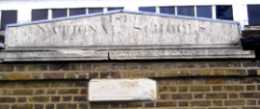 |
National School. |
Carved stones on the building now occupied by the National Spiritualist Church which is opposite the Vestry Museum in Vestry Road. The top inscription states that it was built in 1819 as the National Boys School and was supported by voluntary contribution. When the boys school moved to Orford Road in 1866, the building had a sex change and the lower inscription shows that in 1867 it became a girls school. (See No. 9. on the MAP) |
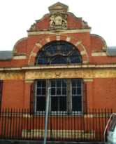 |
The Old Post Sorting Office. |
Vestry Road. Built in 1903 , it has now been converted into an Islamic Centre which includes a Mosque. One must wonder if there are any other mosques in Britain which bear a royal coat of arms. (See No. 10. on the MAP)
|
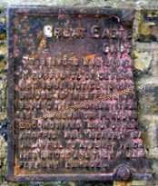 |
Railway Bridge Notice. |
On the bridge in Orford Road over the railway, there is the remains of a public notice placed there by the Great Eastern Railway Company. The date was some time between 1868 and 1923 when the railway became part of the London North Eastern Railway (LNER). Almost a half of the cast iron notice has been broken off the right hand side. The grey letters on the text below are an attempt to reconstruct the text and may not be correct. See also a more complete notice of similar design and date on the Chingford page. (See No. 11. on the MAP)
GREAT EASTERN RAILWAY
CAUTION
TO DRIVERS AND OWNERS
IN PURSUANCE OF SECTION � OF THE �
ACT 1861 NOTICE IS HEREBY GIVEN THAT THIS
BRIDGE IS INSUFFICIENT TO CARRY WEIGHTS
BEYOND THE ORDINARY TRAFFIC OF THE DISTRICT
AND OWNERS OR PERSONS IN CHARGE OF
LOCOMOTIVES AND OTHER VEHICULAR
TRAFFIC ARE HEREBY WARNED THAT IT IS
UNLAWFUL TO ATTEMPT TO DRIVE THEM OVER
THIS BRIDGE AND THEY WILL BE HELD LIABLE
FOR ANY DAMAGE. |
|
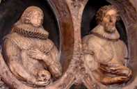 |
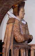
St. Mary's Church |
Church Lane. A church has been here since at least 1130 in the reign of Henry I and was probably built on the site of an older Saxon church. The present building has some Norman features but has been greatly altered over the years. It has many interesting monuments and brasses, the earliest dates back to 1436. The two photos show details from the monuments (which also feature the subjects' children) They are:
Upper. Lucy Lady Stanley (died 1601) who was a member of the Percy family and the daughter of the Earl of Northumberland while her husband was grandson of the Earl of Derby. The sculptor was probably William Cure, master mason of Queen Elizabeth.
Lower. Sir Thomas Merry and his wife Mary. Mary died in 1632. Sir Thomas was Chief Controller under Charles I and probably employed Nicholas Stone, the King's master mason to make it. Note that while Mary is holding a skull to show that she was by then dead, Thomas is holding an open book to show that he was then still living. (See No. 12. on the MAP)
|
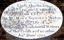 |
Squires Almshouses. |
The notice over the alms houses in Vestry Road states:
Thefe houfes are ERECTED and ENDOWED For EVER
By Mrs Mary Squires for the Ufe of
Six Decayed Tradefmans Widows of this Parifh and no other.
Ano. Domi. 1795.
Note that it is not one might expect that it was the tradesmen who were decayed, but their widows, whose finances were in a state of decay. Secondly, this is an example of parochialism which did not allow those from outside Walthamstow to benefit. The reason was that at that time each parish was responsible for caring for the poor within its borders. (See No. 13. on the MAP) |
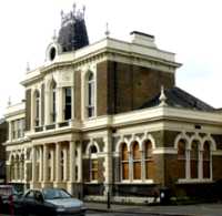 |
The Old Town Hall. |
Orford Road Built in 1876 in the style of a continental chateau. This is one of three buildings from which Walthamstow has been run. Before this, when Walthamstow consisted of just five small villages, the ratepayers met at Vestry House to discuss affairs. By the 1870s it had grown into a suburb and it required a council who erected this building. But as it continued to grow in population it needed even larger premises and moved to Forest Road in 1941. (See No. 14. on the MAP) |
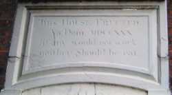 |
Vestry House Museum. |
Over the entrance to the Vestry House Museum in Vestry Road this notice is still displayed. The text reads:-
This House Errected
An. Dom. MDCCXXX
if any would not work
neither Should he eat
|
The building was erected as a workhouse to provide work and the minimum of food for the poorest of the poor. Conditions in workhouses were described by Charles Dickens in "Oliver Twist". The motto over the door reflects the philosophy that guided such places. The church Vestry committee which fulfilled the duties of the later local council, met in this building and so gave rise to the name of museum and of the road. Before 1730, the Vestry committee used to meet at the old Nag's Head or one of the other local inns. The museum has a good variety of interesting exhibits and admission is free. The council has had to economise and the museum now only opens a few days each week. So check its web site before visiting. (See No. 15. on the MAP)
Carved by: Samuel Chandler.
|
 |
The Watch House. |
Notice on the side of the Vestry Museum in Vestry Road. The watch house was built in 1765 and was also known as 'The Cage'. Before there was a police force, the Vestry employed watchmen to keep the peace in the area. If anyone needed to be restrained or if they had to be held to appear before the magistrate, they were confined in the watch house. (See No. 16. on the MAP)
|
 TO READ NAME ~ CLICK FOR PHOTO & EXPLANATION.