| | |
 |
Clement Attlee. |
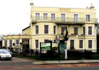
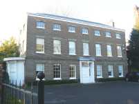
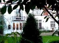
17 Monkhouse Avenue. Clement Attlee (1883-1967) was deputy prime minister 1942-45 under Churchill and following the post war election in 1945 became prime minister. Under his leadership the NHS was started, the basis was laid for the welfare state and India was granted independence. In 1955 he became an earl and in the latter part of his life lived here. (See No. 1. on Map )
|
 |
The Castle. |
The High Road, Woodford Green. Until 1914 Londoners used to visit Woodford in large numbers on day trips stopping off here when visiting the Epping Forest. There has long been a pub on this spot. In 1753 it was known as the Ship and Castle. The High Road was one of two main routes from Leytonstone which existed from Roman times. The other was the Low Road (Now Chingford Road) which follows the Roding valley and used to cross it at Woodford Bridge, which was roughly where the M 11 now bridges the road. (See No. 2. on MAP )
|
 |
Who Was Charlie Brown? |
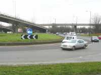
There is nothing to see at Charlie Brown's roundabout but the traffic, yet the name still remains. But who was he? Like so many other places in East London it is connected with a pub. From 1899-1932, Charlie Brown was the landlord of the Railway Tavern near the West India Docks, Limehouse. He put together a large collection of curios and exotica which formed a mini museum. Ship owners did not pay their crews until some days after arrival, so they often landed without cash. Charlie one of the few who would supply them with drink and food (mostly the former) on credit. He was also generous in support of the dockers. For all this he was warmly remembered and his funeral, at what is now Tower Hamlets cemetery, was attended by hundreds of mourners and thousands lined the route. There were 140 floral tributes and the cortege took 20 minutes to pass. In 1938 his son, Charlie junior, opened his own pub here called the Roundabout, but it was known locally as Charlie Brown's. It disappeared in 1972 with the changes to road lay out for the M 11.
(See No. 3. on MAP )
|
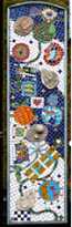 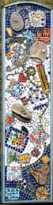 |
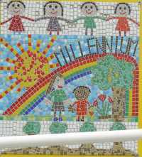
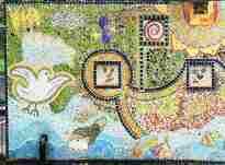
Churchfields Junior School Mosaics. |
Churchfields Road South Woodford. Two of a set of mosaics produced by the pupils to celebrate the millennium in 2000. They now brighten up the exterior of the school buildings. (See No. 4. on MAP )
|
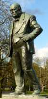 |
Churchill Statue |
The southern end of the green at Woodford Green. Near Broomhall Walk. Sir Winston Churchill (1874-1965) was MP for Wanstead and Woodford constituency for 40 years and was prime minister from 1940-5 and from 1951-52. Churchill was a colourful character who was responsible for the fiasco of Gallipoli in WW1 yet proved to be an inspirational leader in WW2, who undoubtedly saved the country when many thought it was lost. Some people think that this statue is a far better likeness than that in Parliament Square. The statue was unveiled by Field Marshal Montgomery. There is another statue of him in Wanstead. (See No. 5. on MAP )
Sculptor:David McFall. Date: 1959. See also Black Horse by the same artist. |
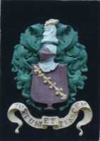  |
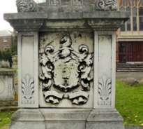
Coat of Arms |
30 The Drive, Woodford. According to Pevsner, The Drive has "a particularly sumptuous display" of houses dating from around 1900. No. 30 displays a coat of arms and a monogram on its front wall. (See No. 6. on MAP )
|
 |
Carved Creation Mural |
Broadmead Baptist Church, Chigwell Road. This mural is no small artwork as it covers the front exterior wall and one side wall. The work depicts the history of the world from the Christian perspective starting with creation and moving through to the crucifixion and resurrection. The panel shown is based upon the second Biblical account of creation as described in Genesis ch. 2 vs. 4 � 25. (See No. 7. on MAP )
Sculptor: Dennis Hull. Date: 1969. |
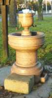 |
Drinking Fountain |
The High Road, Woodford Green. This fountain is at the North end of the triangular grass-covered roundabout at the junction of the High Road and Woodford New Road. The fountain stands under a wooden canopy and was installed by the Metropolitan Fountain and Cattle Trough Association. This is unusual because it still has some of its original metal fittings. Woodford New Road was constructed in 1826, but is still called "new". (See No. 8 . on MAP )
|
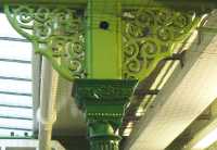 |
The Eastern Counties Railway |
Woodford Underground Station. The design of the cast iron work on the brackets holding up the canopies over the platforms, which may go back to 1856 when the Eastern Counties Railway first opened the line; but is more likely to date from c. 1880. Note also the Victorian style decoration of the pillars. The arrival of the railway heralded great changes to Woodford with a rapid growth of population and the building of houses turning a rural retreat for the wealthy into a suburb of London. In 1947, London Transport took over the railway and electrified the line. (See No. 9. on MAP )
|
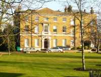 |
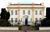
Elmhurst |
Woodford High Road. This is one of the large mansions owned by the very rich people who came to live in Woodford. Built in 1771 by Sylvanus Grove, this was originally called Grove House. Grove was a prosperous London merchant who had financial dealings with the state of Maryland prior to the War of Independence. The house is currently occupied by a number of offices. (See No. 10. on MAP )
|
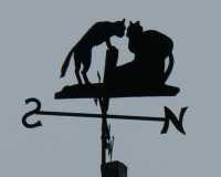 |
"Feline Weathervane." |
51 Derby Road. The western end of this road is blocked off. Derby Road was part of a housing development begun in the 1860s, where the streets were named after members of the cabinet of the Earl of Derby, they were his son Lord Stanley, the others were Sir Robert Peel, Henry Herbert Earl of Carnarvon, Lord Malmesbury, Sir Robert Walpole, and Buckingham. (See No. 11. on MAP )
|
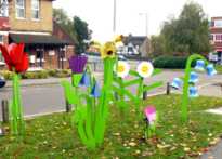 |
"Flowers." |
George Lane, South Woodford. On the central reservation near the roundabout. (See No. 12. on MAP )
Sculptor: Nicola Burrell and pupils of Oakdale Infants, Wells Primary and Churchfields Infants and Junior Schools. |
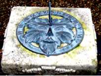 |
Garden of Remembrance. |
Snaresbrook Road, almost opposite to the Eastern end of the Eagle pond enter by an anonymous gate. The sundial is on a small stone pediment in this quiet little garden of remembrance opened in 1997 by the British Legion. The face on the sun dial is that of the legendary green man. There is a simple plaque which says IN REMEMBRANCE OF VICTIMS OF WAR This memorial does not attempt to glorify war, instead it emphasises the universal nature of the suffering that wars cause. (See No. 13. on MAP )
|
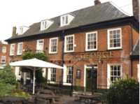 |
The George. |
On the corner of Woodford Road and George Lane, South Woodford. There has been a pub on this site from at least the middle of the 17th century, when it was called the Horns Inn. Part of the present building dates from the 18th century but much was changed and added in the 19th century adaptations. (See No. 14. on MAP )
|
 |
Gipsy Smith Monument. |
Epping Forest a short distance North-west of the Waterworks roundabout. Directions: Starting from the north end of the footbridge over the A406 North Circular Road, walk 200 yards north-east along the bridle path, the monument should then be visible amongst the trees about 40 yards to the west. Gipsy Rodney Smith (1860-1947) was an itinerant Romany who happened to be born in a caravan at this spot in Epping Forest. When quite young, he was converted to Christianity and became one of the first officers in the Salvation Army under the leadership of William Booth. He then became an itinerant preacher and was later awarded the MBE. A Romany caravan is carved on the granite stone. (See No. 15. on MAP )
|
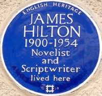 |
James Hilton. |
42 Oakhill Gardens. The house is in a small cul-de-sac off a bigger cul-de-sac. James Hilton was a novelist who wrote among other things "Lost Horizon", "Goodbye Mr Chips" and "Random Harvest". (See No. 16 . on MAP )
|
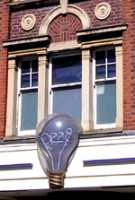 |
Giant Light Bulb. |
Electric Parade, on the corner of George Lane and the High Road. This parade of shops with residential accommodation above was put up in 1925, long before anyone invented energy saving light bulbs. (See No. 17. on MAP )
|
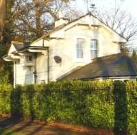 |
The Lodge. |
On the south eastern side of the Green near Snakes Lane West. This was originally the gatehouse at the entrance to Harts, a large mansion and like the main building is Grade II listed. There had been a house here in mediaeval times, but in 1617 Sir Humphrey Handforth who was Master of the Wardrobe to James 1 built an impressive house. In the 18th century it was owned by Richard Warner who laid out a noted botanical garden. More recently it became Harts Hospital and is now a nursing home. Warner gave his name to a path and the pond on the Green. (See No. 18. on MAP )
|
 |
Millennium Mosaic. |
Oakdale Infants School, Woodville Road. On the front wall of the school and visible from the pavement. (See No. 19. on MAP )
|
 |
William Morris Tombstone |
Woodford High Road. Tombstone on the grass in front of St Mary's Church. This is the stone of William who was the father of William Morris the leading light of the Arts and Crafts Movement and the Pre-Raphaelite brotherhood. The family crest is depicted on one end, and some of the decoration on the grave seems to have Morris' style. The family motto is Pax et Libertas meaning Peace and Freedom. William Morris senior lived with his family in Woodford Hall which was situated next door, and the parish Memorial Hall now stands in its former grounds. Woodford Hall had been the manor house for centuries. Among those who had lived there was Sir Thomas Rowe who explored 300 miles up the River Amazon and in 1614 was appointed ambassador by James I and went on important missions to India, where he negotiated a deal which paved the way for the East India Company and to Algiers where he secured the release of 700 British citizens who were being held captive there. A memorial to him is in the church. (See No. 20. on MAP )
|
 |
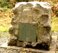
Mussolini's War Crimes. |
Half-hidden by shrubbery in front of 587 High Road, Woodford Green and just north of the Mornington Road turn off. In 1935, Benito Mussolini, then the dictator ruling Italy, wanted to show himself to be a great military leader. Looking for an easy victory he invaded Ethiopia from neighbouring Italian Somaliland and Eritrea. Ethiopia was at that time a poor and backward independent country. Mussolini unleashed upon it the horrors of modern European war. He even used his air force and artillery to deliver bombs and canisters of chemical weapons such as mustard gas and phosgene, which were used against both troops and primitive villagers. The League of Nations declared Italy an aggressor but failed to act against them and so cleared the way for the other Fascist dictators Franco and Hitler. Sylvia Pankhurst, the suffragette and social worker, who then lived in the cottage on this site, was so appalled by this barbarity that she commissioned this sculpture as a protest. The inscription is now hard to read, and only the north face is legible. It originally read:
| SOUTH FACE | EAST FACE | NORTH FACE | WEST FACE |
To those who in 1932
upheld the right to
use bombing
aeroplanes |
This monument
is raised as
a protest against
war in the air |
Originally
Unveiled by
R Zaphiro
Secretary of the
Imperial Ethiopian
Legation London
supported by
James Ranger
E L A Webster
J Davey.
Sylvia PankhurstOctober 20th 1935 |
The site of this
monument is
the property of
Sylvia Pankhurst
Design and work by
Eric Benfield |
(See No. 21. on MAP )
|
 |
The Naked Beauty. |
No. 1 Broomhill Walk. This house was built about 1714 as Hurst House but was named on some maps as the Naked Beauty probably because it stood out at the top of the Salway Hill unshielded by trees. A disastrous fire in the 1930s destroyed much of the original building; but it was then reconstructed to the original design and now looks impressive. The original owner was Henry Raine a philanthropic brewer from Wapping who founded the first Raine's School just 5 years after building this house. (See No. 22. on MAP )
|
 |
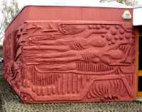
Nightingale Primary School Mural. |
Ashbourne Avenue. The photo shows about half of a very large mosaic which can easily be seen through the perimeter fence. It is a little odd that none of the birds in this mural seem to resemble nightingales. (See No. 23. on MAP )
|
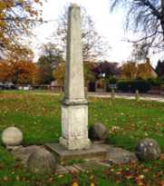 |
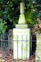
Obelisk. |
On the southern part of The Green, Woodford Green. The spherical stone balls round the base arrived on Woodford Green in 1860. In 1970 they were sold to an antique dealer; but as each one weighed 280 pounds (125 Kg approx.), it is not surprising that he could not sell them, and six years later they were bought by the Woodford Green Amenities Group and set up round this obelisk, which had been erected here in 1934. (See No. 24. on MAP )
|
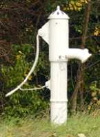 |
Parish Pumps. |
The photo shows the pump at the side of the Chigwell Road between Broadmead Road and Wansford Road. (See No. 25. on MAP ) This is one of four such hand pumps still surviving in the Woodford area. All of these have been renovated. Before water pipes were laid local residents had to rely on these for their water supply. Though unconnected with them, these pumps remind us that Woodford Wells got its name by the 18th century from springs which were thought to have medicinal properties. The other pumps are at:
- Beside Chigwell Road, about 3 yards NE of where the M 11 crosses over it. Errected 1834. (See No. 25a. on MAP )
- Under a willow tree beside the pond at the end of Johnston Road. (See No. 25b. on MAP )
- High Road in the shrubbery nearly opposite the Churchill Statue (See No. 25c. on MAP )
|
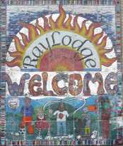 |
Ray Lodge Ceramic Mural |
On the corner of Ray Lodge Road and Baddow Close. This mural made of ceramic tiles is part of the Ray Lodge Refurbishment Project. (See No. 26. on MAP )
|
 |
The Old Rectory. |
Next to St Mary's Church in the High Road. Built about 1800 as a rectory, this shows the status of the minister of this parish. It was later used first as council offices and then for the North east London Quarter Sessions but has now been converted into offices. (See No. 27. on MAP )
|
 |
Repton's Park |
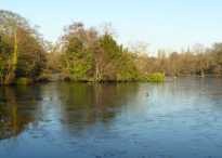
Highams Park. This may be accessed from various directions. Paths lead from Keynsham Avenue, Henry's Avenue, Tamworth Avenue and The Charter Road. The present park is only part of the grounds of the manor of Higham Bensted or Highams as it was often called. The manor existed from at least the Norman period and was listed in the Domesday Book. In the 1790s John Harman employed Humphrey Repton (1752-1818) to suggest alterations to the house and to landscape the gardens into a park. By the 1930s only 28 acres of Repton's 93 acre park still remained. The most recognisable feature visible today is the lake. Later, the house was owned by Edward Warner and his son Thomas Courtenay Warner. (See No. 28. on MAP)
|
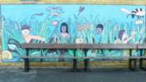 |
St Antony's Mural |
Mornington Road. This painted mural in St Antony's Roman Catholic Primary School is part hidden by benches. (See No. 29. on MAP )
|
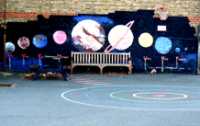 |
The Solar System |
Ray Lodge Primary School, Snakes Lane East. Mural on the side of the building facing the playground. This mural shows it is possible to brighten a play area so that children can learn and play at the same time. The school name is derived from the lodge of Ray House. The lodge was near the present site of the school and the house used to stand in the middle of what is now a green recreational area. The name Ray comes from William Ree who lived here in the 13th century. Snakes Lane has nothing to do with reptiles but was so called because in the middle ages the Sake family had a house there. (See No. 30. on MAP )
|
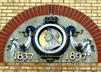 |
Queen Victoria. |
New Jubilee Court, Grange Avenue. Jubilee Court was built on the site occupied by the Jubilee Hospital. This sculptured plaque was taken from the demolished hospital and used as a decoration for this developer's project. The hospital opened in 1899 commemorating Victoria's diamond jubilee in 1897. The webmaster can attest that this was a lovely little cottage hospital with just 54 beds, as he once was a patient there. However in 1985, it was shut down by Kenneth Clarke in a move to centralize to a few large hospitals. Recently, the health service has started encouraging GPs to get together and open their own treatment centres. Plus ça change c'est la même chose. (See No. 31. on MAP )
|
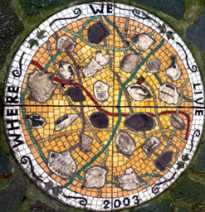 |
"Where We Live." |
Pankhurst Green, Snakes Lane West. The design, which is set in the ground, is a mosaic showing the shapes of leaves of trees that grow in the neighbourhood. All the leaves are named in order to help one identify them. This green is named after Sylvia Pankhurst who lived in a house in Woodford, but was not well received in the area because of her left wing politics and because of her unorthodox way of life. (See No. 32. on MAP )
Date: 2003. |
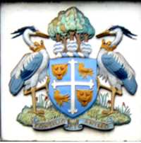 |
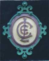
The Old Crest of Wanstead & Woodford. |
On the front of the Sir James Hawkey Hall, Broomhill Road. Note the trees and the river at the top indicate Wood ford, while the heron supporters represent Wanstead. On the shield are leopard's heads and birds (martlets). These are the symbols of King Harold, who gave the manor of Woodford to Waltham Abbey, and of Edward the confessor who gave Wanstead to Westminster Abbey. Wanstead and Woodford merged with Ilford in 1965 to become the Borough of Redbridge. Hawkey served as Mayor of Wanstead & Woodford in the 1940s. (See No. 33. on MAP )
|
 |
Woodford Hall. |
West of the High Road next to St Mary's Church, This used to be the site of the manor house of Woodford, mentioned before the Norman invasion. There was a series of Manor Houses here. In 1869 the last one was sold to a property developer who pulled down most of the existing house. However some traces of the hose and estate remain today. The wall that surrounded the house can be seen in front of houses in Chelmsford and Buckingham roads. There is one wall pillar almost in front of the church to which someone has attached a notice about a remarkable copper beech tree in the churchyard. After 1869 it became Mrs Gladstone's Convalescent Home for the poor, at which time a small chapel was added at the rear. When the Hall was pulled down in 1895, the chapel survived and was converted into a house which is now called Chapel la Frith with its entrance in Buckingham Road. It is possible to see the back of the house, if one is tall enough to look over the wall behind the Memorial Hall, from where this photo was taken. (See No. 34. on MAP )
|
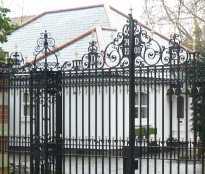 |
Wrought Iron Gates. |
Woodford High Road almost opposite the Eagle pub. These are the gates leading to Snaresbrook House and are clearly dated 1900. The design includes the letters D and S are which are the initials of David Symons who owned the house at that time. The house is thought to have been built in about 1800 but has been much altered. The best place to see the house is from the Garden of Remembrance. (See No. 35. on MAP )
|
 TO READ NAME