 |
BOW.
|
 TO READ NAME ~ CLICK FOR PHOTO & EXPLANATION.
CONTENTS |
||
| 1. "Barge of Invisible Memories". | 2. Bird. | 3. 223 Bow Road |
| 4. Bow Road Business Centre | 5. Bow Road Docks Mosaic | 6. Lord Cardigan |
| 7. Central Foundation Girls School | 8. Clayhall Tea House | 9. "Community Fragments" |
| 10. The Co-op | 11. Fairfield Works | 12. Fishtail Seat |
| 13. Gladstone Statue | 14. Gunmakers Arms | 15. "Heron" |
| 16. Ideas Store | 17. George Lansbury Memorial | 18. Minnie Lansbury Memorial Clock |
| 19. "Lefevre Flowers" | 20. Milestone | 21. The Lord Morpeth |
| 22. A Queen's Mother | 23. St Mary's Church | 24. School Gates |
| 25. Top O' The Morning | 26. War Memorial | 27. Israel Zangwill |
 |
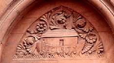
"Barge of Invisible Memories." | |
On the towpath beside the Hertford Union Canal slightly to the east of Gunmakers Lane bridge. Access from Old Ford Road via Birdsfield Lane and Barge Lane. The explanatory notice tells how the work symbolically represents past history of the East End. Although it is basically a horse pulling a barge along the towpath, the horse is a Roman war horse and the prow is the figurehead from HMS Warrior. Incorporated into the intricate tracery of the barge there are references to the London Small Arms Factory, furniture makers and a wallpaper factory. The artist was inspired by thoughts of the barge from the armaments factory which exploded on the Regents Canal in 1874; but he shows a roll of wallpaper exploding out of the barge. (See No. 1. on Map) Artist: Ben Coode-Adams assisted by Arkadius Zykin and Ed Goolden. Date: 2006.
|
||
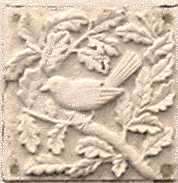  |
Bird. | |
287 Old Ford Road. Many of the buildings on this new housing estate have individually carved stone panels fixed to them. No two are alike. Some (not all) of those in Birdsfield Lane like the right hand picture depict species of birds. (See No. 2. on Map) |
||
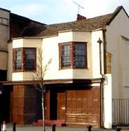 |
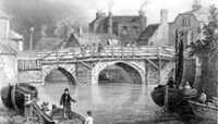
223 Bow Road. | |
No. 223 Bow Road seems to sit rather shyly near to the brash new MacDonald's nearby. The building dates back to the 17th century with its two quaint bay windows on the first floor. Its rounded bays on the ground floor were presumably added later to make a shop front in the rural village of Bow. Probably, the building is not quite old enough to have witnessed the skirmish in June 1648, between the Roundheads and Cavaliers that took place at Bow Bridge during the Civil War. A party of Royalists under the Earl of Norwich who had crossed from Kent and captured the turnpike at the end of Bow Bridge, but they were driven off by the parliamentary forces and then chased as far as Colchester. (See No. 3. on Map) |
||
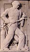 |
Bow Road Business Centre. | |
On the corner of Bow Road and Fairfield Road, E3. Formerly Poplar Town Hall. There are five representations of labourers who built this Town Hall. This is one shows an oxy-acetylene welder. Others show an architect, a stonemason, a navvy and a carpenter. Fairfield Road got it's name from the annual fair which used to beheld in this area of Bow. Originally, James II had given permission for a May Fair to be held in the West End near Piccadilly, but in 1764 the Earl of Coventry had it moved to Bow. So the fair gave rise to the names of both this road and the area of Mayfair. (See No. 4. on Map) Artist: David Evans. Date: 1938.
|
||
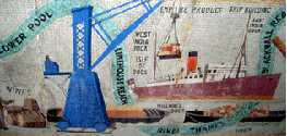 |
Bow Road Business Centre Mosaic. | |
Part of the mosaic over the other entrance of the same building there is an awning, on the front of which are 5 small mosaics. But on the under side of the awning there is a large mosaic depicting a schematic map of the river Thames, showing some of the activities then taking place in the docks. (See No. 5. on Map) Designer: David Evans, 1938. | ||
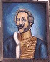 |
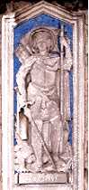
Lord Cardigan. | |
Pub on the corner of Anglo Road and Cardigan Road. Lord Cardigan (1797 � 1868), as a major-general, led the suicidal charge of the Light Brigade at the Battle of Balaclava in the Crimean War. Some say that it was his impetuous nature which contributed to this disastrous action. However, on his return to England he was regarded as a hero rather than as an idiot and this pub and road were named in his honour. The woollen garment he wore in the battle was called a cardigan but the balaclava helmet was named after the battle. (See No. 6. on Map) | ||
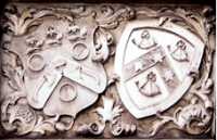 |
Central Foundation Girls School (Lower). |
|
Bow Road, between Coborn Street and Harley Grove. On the front of this 1898 building is a large carved stone saying STEPNEY & BOW FOUNDATION COBORN GIRLS SCHOOL. A second stone, shown here, has two coats of arms and two dates. 1538 and 1701. 1701 was the year that a wealthy widow named Prisca Coborn died and left money and land to establish a free school for 50 poor children. The boys were taught the three Rs � Reading, Writing and Arithmetic. While the girls learnt needle work instead of Mathematics. This school was originally near Bow Church. In 1891 it amalgamated with the Stepney & Bow Foundation Schools run by the Coopers Company and they built this school in 1896. 1538 on the left hand side refers to the Coopers Guild which dates back to the 1400s and the Coopers Company received their charter in 1501. (See No. 7. on Map) |
||
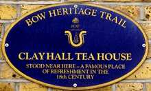 |
Clayhall Tea House. | |
On the front wall of 50 Blondin Street. In the 18th century, Londoners wanting to go for a jaunt into the country, often used to visit this tea house, which was situated to the east of the plaque. Some time before this, Samuel Pepys described in his diary how he visited Bow and had eaten a memorable dish of cherries and cream here. (See No. 8. on Map) | ||
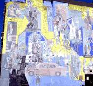 |
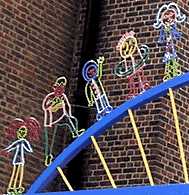
"Community Fragments." | |
Merchant Street. Large mural on the Merchant Street Surgery which is entitled "Community Fragments". This is a lively mural showing local scenes, but some of the colours, particularly the reds, have now faded, leaving yellow to be one of the dominant colours. The visitor is left wondering whether the notice on the wall which states "Yellow Fever Centre" has any connection with the artwork. (See No. 9. on Map) Artist: Ray Walker. Restored by David Bratby in 1986. |
||
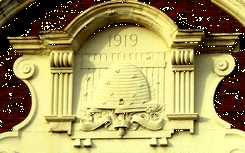 |
The Co-op. | |
Bow Road near the junction with Fairfield Road. The beehive was the symbol of workers co-operating. There is another example of the same symbol. The co-op purchased goods in bulk at low prices and instead of giving the profits to shareholders passed on the benefits the customers who were members of the society which owned the stores. This building used to belong to the Stratford Co-Operative & Industrial Society and was built in 1919. (See No. 10. on Map) |
||
 |
Fairfield Works. | |
Fairfield Road. This massive set of buildings was probably the most important match factory in Britain. The company was called Bryant and Mays. It was formed by the amalgamation of two factories owned by families with these names. The factory became famous for its products and notorious for the lack of concern for its work force. The health hazards of the work and the poor pay given eventually led to the Match Girls' Strike of 1888. (See also Gladstone Statue) With the help and inspiration of Annie Besant they were successful in gaining better conditions. This led to the founding of the Matchmakers Union with Annie Besant as the secretary. She later served as President of the Indian National Congress. The representation of Noah's Ark ironically with the word "Security" on it was used as a trade mark on their matchboxes. Match production ceased in 1979 and the main building is now used for private apartments. (See No. 11. on Map) |
||
|
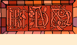
Can You Read This?On the wall of cottage number 5 there is a group of three monograms. These are terracotta tiles. They are not visible from the road, but you may be able to persuade the security men on the door to let you see them. If you are unable to decipher the message, then HOLD THE MOUSE OVER THE PICTURE for the answer. |
|
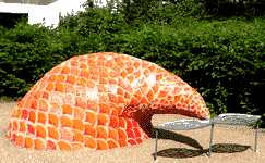 |
Fishtail Seat. |
|
By the side of the towpath of the Grand Union Canal just south of where Roman Road crosses it. The scales of the fish are of baked glazed tiles many of which have on them designs made by children. In some cases the children have written their names as well. Many of their designs are based on marine subjects. . (See No. 12. on Map) |
||
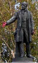 |
Gladstone Statue. | |
By Bow Church, Bow Road, E3. William Ewart Gladstone, Liberal Prime Minister for several periods between 1868 and 1894. The statue was donated by Theodore H Bryant director of the nearby Bryant & Mays match factory. At the time, the factory was notorious for the number of its women workers who were disfigured or who died of "phossy jaw", poisoning from the white phosphorus in the matches which they were making. The factory is remembered for the campaign of Annie Besant and the Match girls' Strike of 1888. The hands of the statue have been painted red because the blood of so many workers was on the hands of the donor of the statue. (See No. 13. on Map) Sculptor: Albert Bruce-Joy, 1882. |
||
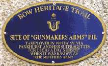 |
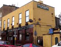
"The Gunmakers Arms." | |
91-94 Tait Court, Old Ford Road. In 1915 Sylvia Pankhurst obtained No. 438, an ex-public house called the Gunmaker's Arms and as an ardent Pacifist, she aptly renamed it the Mother's Arms. She used it as a clinic for mothers and babies and as a cr�che, which allowed poor mothers to go out and earn some money to support themselves. Later she also opened a soup kitchen to feed the local poor. The Gunmakers Arms got its name from the Gunmakers Wharf opposite, where there used to be the London Small Arms Factory. This was an important arms producer during the 1914-18 war. It was sited here so that it could transport parts on the canal to and from their other factory in Enfield. (See No. 14. on Map) |
||
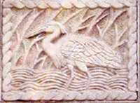 |
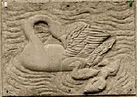
"Heron." | |
Waterside Close off Parnell Road. One of five hand carved representations of British birds set into the walls of this housing estate. The other birds are Pheasant, Kingfisher, Dove and Blackbirds. The Heron is between no. 1 and no. 2. (See No. 15. on Map) Sculptor: Paula Haughney. 1996. (See also by the same artist: "Dockers' Memories" , "Exotic Birds" etc. "The Passenger" , "Ram and Magpie" and "Smiling Beast" |
||
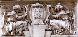 |
Ideas Store. | |
Gladstone Place off Roman Road. This building was erected in 1901 as the Passmore Edwards Public Library of Bow, but is now known as the Ideas Store. It serves as a library and for other educational purposes. These two cherubic figures are over the main entrance while the original name plaque is on the corner of the building. . (See No. 16. on Map) Sculptor: H. C. Fehr. Date 1901. | ||
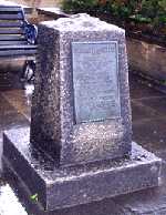 |
George Lansbury Memorial. | |
Situated at the corner of Bow Road and Harley Grove, outside the flats that bear his name. This stone in memory of George Lansbury (1859-1940) describes him as "A great servant of the people." He was elected to parliament in 1911, but resigned his seat to electioneer as a "Votes For Women" candidate. At this election he failed to get in. Lansbury was twice Mayor of Poplar. In 1921, when he was mayor, the council refused to levy disproportionately high rates on the poor, which they felt were benefiting the rich. The council members were summoned to appear in court. They marched to court in a procession, led by the mace-bearer, and accompanied by a band and a banner. 30 councillors were sent to prison for contempt of court. But Lansbury was later elected MP and was made a Privy Counsellor. He was leader of the Labour Party 1931-35. (See No. 17. on Map) |
||
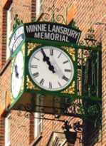 |
Minnie Lansbury Memorial Clock. | |
Bow Road over a small row of shops near the junction with Alfred Street. Minnie Lansbury was a daughter-Law of George Lansbury, and served on Poplar Council. She was one of the 30 councillors sent to prison for not raising the required rates. (See George Lansbury Memorial.) The 24 men were sent to Brixton prison and the six women were sent to Holloway. Conditions in prison were not good, and several councillors became ill. Minnie died at the age of 32, six weeks after being released from prison. Her death was partly due to her imprisonment. This was not the first time that she had been imprisoned. Previously, it had been because of her involvement in the campaign to give women a vote. On the wall beneath the clock are two plaques. One dates from the original setting up of the clock and the other records its renovation in 2008. (See No. 18. on Map) |
||
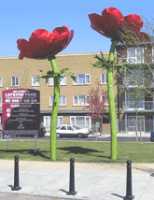 |
"Lefevre Flowers." | |
The eastern end of Roman road, in a green area called Lefevre Park which is opposite Mercury House. These are two giant anemones which are 5 and 6 metres high respectively. Compare their height to the standard size bollards in the foreground. The artist produced the work following consultation with local residents, and designed "these two flowers as beacons to be glimpsed from the Roman Road market and as celebratory markers of a beautiful place being created to replace an ugly one." Artist: Helena Roden. Metalworker, Gideon Petersen Date: 2005. (See also "Old Ford Primary School Gates" and "Steven Hawking School Gates" by the same artist.) |
||
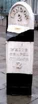 |
Milestone. | |
In Bow Road on the left hand side leaving the centre of London, near the junction with Alfred Street. On the top is written Bow Parish on the hidden face is written Stratford 1�. To be accurate, this is not a milestone as it appears to be cast iron. At one time these would be placed at regular mile intervals by the side of major roads. This is a rare survivor, but is clearly not very old as the distance is measured to the White Chapel rather than to the London city boundary at Aldgate. It is also proof that Mile End Station is some distance east of the Old Mile End. (See No. 20. on Map) |
||
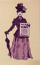 |
Lord Morpeth. | |
Pub sign. Old Ford Road, E3. Lord Morpeth (1781 � 1855), was an MP, who had nothing to do with the suffragette movement. In 1829, he spoke out in favour of giving political rights to Roman Catholics and Jews. He served as Chief Secretary to Ireland and later sat in the House of Lords. The sign shows a very sedate-looking suffragette with a placard. This commemorates the fact that Sylvia Pankhurst (1882-1960), daughter of Emmeline Pankhurst, had lived with Norah Smyth in the building at 400 Old Ford Road, which is no longer standing. She took over 45 Norman Road and turned it into a toy factory, giving employment for women. Bow Heritage Trail has placed a plaque on the side wall of the Lord Morpeth. (See also The Gunmakers Arms) Until mid 2006 the pub sign was far more colourful (in both senses of the word). The old sign is shown on the front page of this web site
|
||
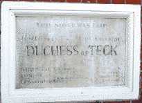 |
A Queen's Mother | |
Saxon Lea Court at the beginning of Saxon Road. The foundation stone of the Hall of what used to be St Stephen's National Schools, but is now apartments. This stone was laid in November 1893 by the Duchess of Teck. Mary, Duchess of Teck was a minor royal, being a grand daughter of George III. She became better known through her daughter also named Mary. The daughter often called Princess May (picture in Jubilee Crescent, Cubit Town) was first engaged in 1892 to Prince Albert Victor, Duke of Clarence, eldest son of Edward, Prince of Wales; but 6 weeks after the engagement was announced Albert Victor died in a flu epidemic. Prince George, Duke of York, the second son who later became George V, proposed to her in 1893 and they were married in July of that year. The Duchess was therefore the grand daughter of George III, the niece of George IV and the mother-in-law of George V. (See No. 22. on Map) |
||
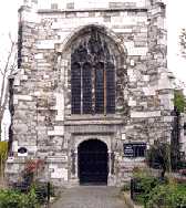 |
St Mary's Church. | |
Situated on the traffic island in Bow Road. Parts of this church date back to 1311, when it was built as a chapel of ease. This term means that it was built to make life easier for local residents, so they did not have to walk all the way to St Dunstan's in Stepney, when they wished to worship. The base of this bell tower is from the late 1400s, but the brickwork of the upper section was a repair made to bomb damage sustained in world war 2. The great bell of Bow features in the rhyme Oranges and Lemons. For hundreds of years this church has stood isolated with a road on each side. In 1912 Sylvia Pankhurst took over a shop at no. 198 Bow Road, opposite the church. Where the shop name had been, she painted "VOTES FOR WOMEN", and used the premises as HQ for her Suffragettes. (See No. 23. on Map) |
||
 |
School Gates. |
|
Old Ford Primary School on the corner of Allen Road and Wrights Road. This is a small detail from a large pair of colourful gates with adjacent railings which were inspired by children's drawings. (See No. 24. on Map) Sculptress: Helena Roden. (See also "Lefevre Flowers" and "Steven Hawking School Gates" by the same artist) | ||
 |
Top O' The Morning. | |
129 Cadogan Terrace. This pub is specially distinguished because it was connected to the first murder to have taken place on a British railway train. In 1864 Franz Muller robbed a passenger called Thomas Briggs and mortally wounded him. He then pushed him out of the train. He was found still alive by the side of the track, and carried into this pub, but died there some hours later. There is a plaque on the front of the pub commemorating the event. This is not the only East End pub that advertises it's macabre past. See also the Blind Beggar, the Prospect of Whitby and the Town of Ramsgate. Publicans obviously believe that such events attract customers. (See No. 25. on Map) |
||
 |
War Memorial. |
|
On the wall of St Barnabas Church which is on the corner of Roman Road and Grove Road. This memorial for those who were killed in the 1914-18 war can be seen from Roman Road. (See No. 26. on Map) | 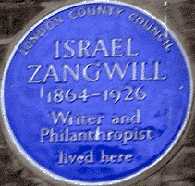 |
Israel Zangwill. |
288 Old Ford Road. Israel Zangwill was a prominent Anglo-Jewish writer. Born in England of Russian Jewish parents, Zangwill started out as a teacher in the Jewish Free School, but soon began to write short stories, then novels and poetry. In some of these he describes the problems of an ancient people coming to terms with life in a modern western country. (See No. 27. on Map) | ||
|| Beckton || Bethnal Green || Blackwall || Bromley-by-Bow || Canary Wharf || Canning Town || Chingford || Cubit Town || Custom House || East Ham || East India Dock || Forest Gate || Higham's Park || Leyton || Leytonstone || Limehouse || Little Ilford || Manor Park || Mile End || Millwall || North Woolwich || Plaistow || Plashet || Poplar || St George's || St Katharine Dock || Shadwell || Shoreditch || Silvertown || Snaresbrook || Spitalfields || Stepney || Stratford || Upton || Walthamstow East || Walthamstow Village || Walthamstow West || Wanstead || Wapping || West India Dock || Whitechapel || Woodford || |
