E 12. MANOR PARK, LITTLE ILFORD.
| Manor Park got it's name from a 19th century railway station. Before that and well into the 20th century it was known as Little Ilford. This distinguished it from Great Ilford on the other side of the river Roding. The Roding was originally called the Hile and so the houses by the ford of the Hile were known as Ilford. Little Ilford was an appropriate name, as it was the smallest parish in the Becontree Hundred and the Domesday Book stated that it only had 10 inhabitants. The name Manor Park was given to the station because of the manor house called Aldersbrook house which used to be near to the present City of London Cemetery and Manor Farm which was close to the present Library. In the 14th century the house was known as Naked Hawe House. In the 16th century it was owned by the Heron family, one of whom married the daughter of Sir Thomas More. Later it belonged to Robert Dudley, Earl of Leicester, who was a favourite of Queen Elizabeth 1. |
PUT MOUSE OVER  TO READ NAME ~ CLICK FOR PHOTO & EXPLANATION.
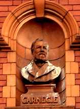 |
Andrew Carnegie. |
|
The Rabbits Road wall of the Carnegie Library Romford Road, Manor Park. Andrew Carnegie (1835 – 1919) was born of humble parents in Scotland and while he was still a youth his family emigrated to America. After several other jobs he made a fortune in the Pennsylvania Railroad and then as head of a large Iron and Steel corporation. He later donated millions of pounds to charitable causes. He was particularly interested in education and helped to found several libraries in East London. Others were at Walthamstow, East Ham, Leyton and Custom House. This library stands on the site, which from 1826-1880 had been occupied by a gaol and a law court. Rabbits Road gets its name from the pub that stood on the site of the chemists shop, opposite. It was called the Three Rabbits, and this in turn was so named because the area was known for it's rabbit warrens. Thomas Hood, who lived not far away at Lake House, Wanstead, in about 1833 described the pub in his book Tylney Hall, as having a sign of three Chinese pigs with long ears which would have puzzled a zoologist but for the superscription – "The Rabbits"; while a writing underneath…(stated) that this establishment was kept by - for it does not keep him - one Jonas Hanway. (See No. 1. on the MAP ) Date: 1904. |
||
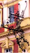 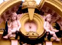 |
"The Earl of Essex." |
|
On the corner of High Street North with Romford Road. The bottom photo shows two childlike figures and between these figures there is the remnant of the gas fitting which supplied the original lighting. The upper photo shows an ornate wrought iron bracket from which the pub sign used to hang. Because the sign is missing it is not clear after which earl the pub is named. It might have been:
|
||
 |
Essex Man Frieze. |
|
The photo part of a long frieze in High Street North in Manor Park. This shows figures in silhouette made in a shiny silvery material. (See No. 3. on the MAP ) |
||
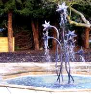 |
Flower Fountain. |
|
City of London Cemetery, Aldesbrook Road. By the restaurant area near the main entrance. This may be seen through the railings at the front of the cemetery. The water emerges from the flower heads. (See No. 4. on the MAP ) |
||
 |
Froud Centre Mosaic. |
|
1 Toronto Avenue, E12. Attached to St Michael and All Angels Church, Romford Road. (See No. 5. on the MAP ) |
||
 |
Janitor's Gateway. |
|
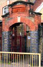
Monega Junior School, Monega Road. Besides having separate entrances for boys and girls, this school has an impressive special gateway for the caretaker. This has the word Caretaker carved over it in large letters. Either they valued their caretakers more highly in 1905 than we do today or else they went to great lengths to keep them away from the children. (See No. 6. on the MAP ) |
||
 |
Little Ilford Mural. |
|
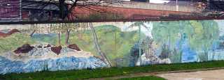
On the boundary wall of Twelve Acre House, 38 Grantham Road, E12. The mural can also be viewed from Romford Road. (See No. 7. on the MAP ) |
||
 |
Little Ilford Lights. |
|
Beside the Romford Road close to the Little Ilford Mural and the boundary with Ilford there are four vertical lamp columns. These columns are cut out to form the leaves of four types of trees. They are Lime, Oak, Holly and Ash. The one shown here is Holly. They are best viewed when lit up after dark, when the leaves show up dark against the background of the inner light. (See No. 8. on the MAP ) |
||
  |
London Sri Murugan Temple. |
|
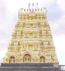
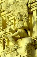
Browning Road. The photo only shows a parts of the very ornately decorated building. On the left shows the top of the central tower together and on the right one of the figures featured on it. One worshipper said that this represents Kobram, a Tamil name which may not be spelt correctly here. The temple was built by people from Southern India and Sri Lanka and the decorations follow the Tamil traditions. (See No. 9. on the MAP ) Date: 2005. |
||
 |
London Tilbury and Southend Railway. |
|
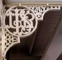
Cast iron mouldings on brackets holding up the roof of East Ham Station. The monogram contains the letters LTSR and stand for the London, Tilbury and Southend Railway. Examples of these can also be seen at Bromley-By-Bow, Plaistow and Upton Park stations. The LTSR began a passenger service on this route using coal-burning steam engines in 1858. The railway was taken over by the London Midland Railway in 1912. The underground started to run through here in 1902. Some of benches on the platforms also have LTSR monograms, which makes them at least 96 years old. (See No. 10. on the MAP ) |
||
 |
St Mary's Church. |
|
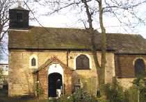
At the junction of Church Road with Winefride's Avenue. This little church with a small wooden bell tower is about 600 years older than any other building in E 12. It is a tiny mediaeval village church hidden away amongst 20th century urban housing. Parts of the church date back to the 12th century, but it has been much altered and rebuilt over the centuries. Archaeologists have discovered some evidence to suggest that this stone church replaced an even earlier wooden building that occupied the same site. (See No. 11. on the MAP ) |
||
 |
St Michael. |
|
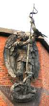
St Michael and All Angels Church in Romford Road, E12. Showing St Michael killing a dragon. Romford Road follows the line of an old Roman road which ran from London to Colchester. Parts of this can still be traced on a map. To the west the Romford Road goes as far as Stratford it disappears under Stratford and it's railway lines and we can pick it up again crossing the Lea valley by a ford on a brick causeway. Beyond the ford the road divides one fork follows Old Ford Road and the other still bears the name Roman Road. Each was clearly laid out to join up with Romford Road, but today they do not converge. To the East the Road becomes Ilford High Road, London Road and beyond Gallows Corner becomes the A12 Colchester Road. It must have been along this road that in AD 61, Boudicca led her Iceni clansmen from Essex to sack Roman London, in order to avenge the ill treatment that she had received at the hands of the Romans, when she had been publicly whipped and her daughters raped. (See No. 12. on the MAP ) Sculptor: Robert H. Crutchley. Date: 1990. |
||
 |
Spiderman. |
|
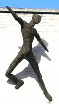
Wordsworth Avenue. The building is occupied by Placement Services dealing with fostering and adoption. The figure stands out from the wall at an alarming angle. It must be the suction pads on his feet that are holding him up, so in the absence of a plaque showing the real title of the work, this photo is headed Spiderman. (See No. 13. on the MAP ) Sculptor: Peter Peri. Date: 1964. |
||
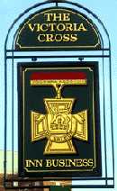 |
The Victoria Cross. |
|
Sign of a pub in Jack Cornwell Street, E12. Jack Trevers Cornwell was the youngest person to be awarded the Victoria Cross. He was awarded it for bravery at the battle of Jutland in 1916. Aged 16, he was a gunner on HMS Chester. Early in the battle he was mortally wounded and the rest of the gun crew were killed; but he stayed at his post until the end of the battle awaiting orders to leave. He was the subject of the poem "The boy stood on the burning deck." His grave is in Manor Park Cemetery, Whitta Road, E12. (See No. 14. on the MAP ) |
||
OTHER AREAS COVERED:-
|| Beckton || Bethnal Green || Blackwall || Bow || Bromley-by-Bow || Canary Wharf || Canning Town || Chingford || Cubit Town || Custom House || East Ham || East India Dock || Forest Gate || Higham's Park || Leyton || Leytonstone || Limehouse || Mile End || Millwall || North Woolwich || Plaistow || Plashet || Poplar || St George's || St Katharine Dock || Shadwell || Shoreditch || Silvertown || Snaresbrook || Spitalfields || Stepney || Stratford || Upton || Walthamstow East || Walthamstow Village || Walthamstow West || Wanstead || Wapping || West India Dock || Whitechapel || Woodford || |