| | |
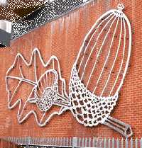 |
The Giant Acorn. (?) |
Near Leamouth roundabout, on the wall of Switch House. This is partly hidden by the office of the Electron Marketing Suite. If "tall oaks from little acorns grow," what should we expect from this acorn which is over 16 foot tall? (See No. 1. on the MAP )
|
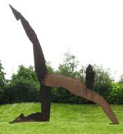 |
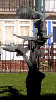
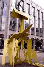
"Aerobic". |
On Leamouth roundabout facing north. A metal sculpture of large proportions. (See No. 2. on the MAP )
Sculptor: Allen James.
|
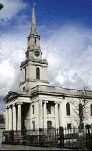 |
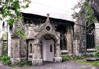
All Saints Church. |
Newby Place. Its spire is a landmark visible from afar. This elegant church was designed by Charles Hollis and dates from 1820-23. (See No. 3. on the MAP )
 All Saints Church All Saints Church
|
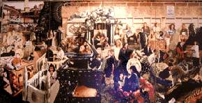 |
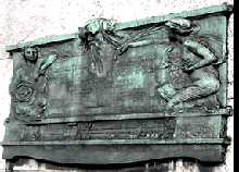
"Awakening." |
In the foyer of the Town Hall in Mulberry Place. This work is based upon Stanley Spence's "Resurrection" and symbolises the reshaping of the East End by the development in Docklands. Canary Wharf Tower can be seen in the top left of the work.
(Reproduced by the courtesy of Tower Hamlets Council)
The Town Hall is built on reclaimed land. For this area was previously the East India unloading Dock. (See B on the 19th century view of area.) In 1944 this is where some of the concrete blocks were made which were used in the Normandy landings in World War 2. These blocks filled with air were floated and towed across the channel and then sunk to form the breakwater of Mulberry Harbour and so enabled troops and supplies to be landed. Hence the name Mulberry Place. (See No. 4. on the MAP )
Artists: Loraine Leeson, Peter Dunn and a team of others from George Green's School on the Isle of Dogs. 1995.
|
 |
"Birdbath." |
Carion Close, which runs between Carmen Street and Cordelia Road. This is in a grassy area and surrounded by a low fence. This is more of a sculpture than a birdbath. It was difficult to ascertain whether the structure held water for birds, on the two occasions when it was observed no birds were seen using it. (See No. 5. on the MAP )
Sculptor: Raymond Arnott. Date: 1959-60.
|
 |
Blackwall Tunnel Memorial.
|
Almost underneath East India Dock Road, on the Eastern wall of the southbound carriageway.
This is the original plaque put up when the tunnel was first opened in 1897. In 1959, when the newer western tunnel was dug, the inscription was moved to its present position. (See No. 6. on the MAP )
Blackwall Tunnel History
Blackwall Tunnel Construction
| |
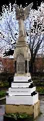 |
Children's Memorial. |
In Poplar Park, East India Dock Road. The memorial was put up to remember 18 children each aged five years old who were killed in 1917 by a bomb dropped from a Gotha bomber aircraft in a daylight raid in World War 1. The bomb hit a school in Great North Street. . (See No. 7. on the MAP )
Sculptor: A.R.Adams.
|
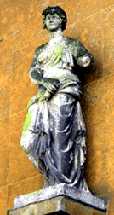 |
Classical Statue. |
On the wall of the Susan Lawrence Primary School in Cordelia Road. The school occupies the site of a pub called The Horn of Plenty which was damaged in the airraids in World War 2. The statue was one of several that adorned Randall's Market which used to be nearby. It is thought to be a copy, made about 1800, of a classical sculpture. Susan Lawrence (1871-1947) was a prominent member of the Poplar Council she was one of those sent to prison over the Poplar rates protest and was also the first woman to serve on the London County Council. She became an MP and in 1930 became the first woman to be chairman of the Labour Party. (See No. 8. on the MAP )
| |
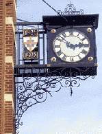 |
Centenary Clock. |
On a building in East India Dock Road. This was originally George Green School, and the clock was made in 1928 to mark the centenary of the school. George Green was a shipbuilder who used much of the money he made for communal purposes. His son's statue is just up the road. (See No. 9. on the MAP )
| |
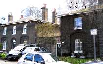 |
Constables' Houses. |
Nos 10-18 Garford Street. These were designed by John Rennie and built in 1807 to house some of the newly-formed Dock Police Force. The high rate of theft while goods were unloaded made it necessary to have docks with high walls and locked gates and a regular police force to enforce the law. The house in the middle of the row is larger as it was designed for the sergeant and his family. (See No. 10. on the MAP )
| |
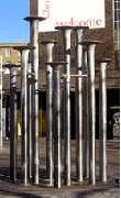 |
Crisp Street Market Fountain. |
In front of the East India Dock Road entrance to the market.. Metal sculpture apparently depicting a group of very large wood nails. It was originally a fountain and was put in by the London Docks Development Corporation in 1989. (See No. 11. on the MAP )
|
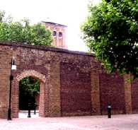 |
Dock Wall. |
Naval Row. This is a section of the 20 foot high brick wall that surrounded the East India Docks. (Letter C on the 1808 picture ) The tall building whose top part shows above the wall can also be seen in the old picture. On an 1839 map, this was called the Mast House. A crane on the tower used to lift the masts into position on the ships alongside. The first Mast House shown in 1808 was made of wood and built in the 1790s for the shipyard that was here before the West and East India docks were built in 1803. Before the 19th century, ships anchored in tideway of the Thames and unloaded their cargos onto small ships and lighters, which took them to the shore, where they were unloaded a second time. A large portion of some cargos went astray before reaching the warehouses. The inland docks with surrounding walls and guarded dock gates were built to prevent this large scale theft. The East India docks were built in 1803-6 by the East India Company who had been associated with the area from the beginning of the 17th century, when they had a shipyard in Blackwall. On 1808 picture ) some ships can be seen on land to right of the Mast House and between it and a small inlet of water. These ships are in the old East India Co ship yards which went back to about 1612. The engineers for the new dock were John Rennie and Ralph Walker. (See No. 12. on the MAP )
East India Docks
|
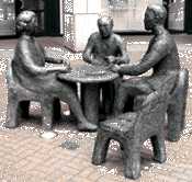 |
"The Domino Players." |
In Clove Crescent, outside the Lighterman Building. 50 years ago, a sculpture placed here would have sunk into the deep water of East India dock. The names of the streets Clove Crescent and Saffron Avenue are reminders of the spices imported through these docks. (See No. 13. on the MAP )
Sculptor: Kim Bennet.
|
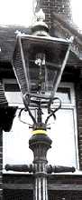 |
Gas Street Lamp |
Mallam Gardens. There are 4 old gas street lamps here.
Not all are complete. The two bars sticking out on either side provide support for a ladder during maintenance. The gas heats delicate mantles which glow and so provide light. These mantles often need to be changed. (See No. 14. on the MAP )
|
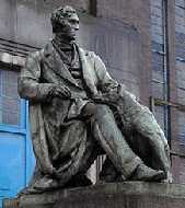 |
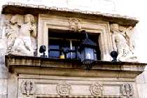
Richard Green (and his one-eared dog). |
Outside the Public Baths in East India Dock Road. Sir Richard Green succeeded his father George Green as a ship builder. There are two carved reliefs on the base of the statue which show ships under construction. If you look carefully at the dog you will see that it's right ear is missing. When the building behind was being used as swimming baths, some youngsters were fooling around after their swim. One threw the other's swimming costume over the statue. The boy climbed up to retrieve it, slipped and got his arm trapped between the dog and his master. The only way that he could be rescued by the fire service was by cutting off the dog's ear. (See No. 15. on the MAP )
Sculptor: Edward W.Wyon.(1811-1885). Date: 1865/6.
Richard Green
|
 |
Holy Family School Mural. |
Wade's Place. Founded in 1816, this is London's oldest Roman Catholic school. (See No. 16. on the MAP )
|
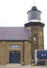 |
London's Only Lighthouse. |
Trinity Buoy Wharf at the end of Orchard Place, Leamouth. Situated at the mouth of the river Lea, Trinity House, who are responsible for marine safety, set up an establishment here in mid 1700s. The lighthouse which was only used for experimental purposes, dates from 1864. One of the scientific advisers here was Michael Faraday. It was his experiments here that prepared the way for the first electric powered lighthouse at Dover. Trinity house still tests buoys and other equipment here. The place is open for visitors on Saturdays and Sundays from 9.0 am to 6.0 p.m. (See No. 17. on the MAP )
Trinity Buoy Wharf
|
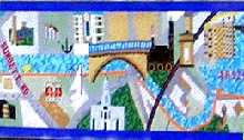 |
Limehouse Cut Mosaic. |
By the side of Limehouse Cut near the bridge where Morris Road crosses the canal. The mosaic shows the route of the canal and some buildings beside it. The Cut, opened in 1770, provided the means to carry goods by water from the docks to the inland waterways. For many years it was full of barge traffic, but after the railways were built in the mid 19th century it was used less and less. The illustration, which is just part of a long mosaic, shows the canal entering the Limehouse Basin. (See No. 18. on the MAP )
|
 |
"Meridians and Metaphors."
|
Beside the pond near the junction of Clove Crescent and Saffron Avenue. The sculpture is situated on the Greenwich meridian. This sculpture is in an area that was formerly occupied by the East India Dock. (Letter G on the 1808 picture ) (See No. 19. on the MAP )
Sculptor: David Jacobson.
|
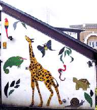 |
Poplar Play Centre.
|
The main entrance is in Poplar High Street, but these designs are on the back of the building and can be seen from the churchyard of St Mathias Old Church with the entrance in Woodstock Terrace. The animals appear to be cut out shapes of boarding which have been painted. (See No. 20. on the MAP )
|
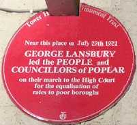 |
Poplar Rates March Plaque. |
203 East India Dock Road. This plaque commemorates events of 1921 when the Poplar Council led a revolt against the unfairness of the rates system, whereby the people living in poorer boroughs were required to pay a greater proportion of their income on rates than those in the more prosperous boroughs. The mayor and councillors who led the revolt were imprisoned, but eventually it resulted an easing of the burdens placed on the poor. The plaque commemorating this brave stand has now been partly hidden by a sign advertising the off licence occupying the building. (See No. 21. on the MAP )
The Rates Protest
|
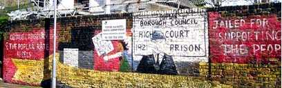 |
Poplar Rates Protest Mural. |
Hale Street. This commemorates the events of 1921 when George Lansbury was mayor of Poplar and the government required all boroughs to pay to a central fund to pay for municipal expenses. Poplar council refused to pay the money on the grounds that they were one of the poorest areas in Britain and that they were being asked to subsidise the richer boroughs. The mayor and counsellors were summoned to appear in court for non-payment. So Lansbury as mayor marched to court in a procession accompanied by counsel members and preceded by his official macebearer together with a brass band and banner-waving supporters. The mayor and counsellors were found guilty of contempt of court and imprisoned for a short period. Although the Poplar council were widely condemned for their stand, their action was the catalyst which caused the introduction of a fairer system of assessing the rates.
(See also the Memorial to Landsbury). The mural was painted as part of the protest against Maggie Thatcher's Poll Tax and the local council paid the artist's expenses. More recently they paid for the restoration of the mural. (See No. 22. on the MAP )
Artist: Mark Francis. Date: 1990.
George Lansbury
|
 |
"Renaissance." |
By the pond at the junction of Saffron Avenue and Clove Crescent. This kiss seems to have swept the lady off her feet. She appears to be flying as if she was a 3D version of a Chagal character. This statue is placed roughly in the middle of where the East India Dock used to be. On the 1808 picture it would be a little to the left and slightly forward of the letter G. (See No. 23. on the MAP )
Sculptor: Maurice Blick.
Maurice Blick
|
 |
St Matthias Church. |
Poplar Recreation Ground. Built originally in 1654 by the East India Company as a chapel of ease close to the docks, it is the only example in London of a church built during the Commonwealth that still survives. The upper picture shows the arms of the East India Company on the ceiling above the nave. The interior columns holding up the ceiling are made of massive tree trunks, said to be from the masts of East Indiamen. The exterior was "Victorianised", so the outward appearance is deceiving. The building is now used as a community centre. (See No. 24. on the MAP )
|
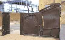 |
Salome Gates. |
In Orchard Place, Leamouth, near a T junction. These are the gates at the entrance to the nature reserve. (See No. 25. on the MAP )
Sculptor: Sir Anthony Caro.
Anthony Caro
|
 |
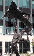
"Shadow Play." |
In front of Compass House in Mulberry Place. A large sculpture in steel and bronze depicting some recreational pastimes of adults and children. (See No. 26. on the MAP )
Sculptor: Dave King. 1992.
|
 |
Tower Hamlets College.
|
Poplar High Street. The carvings round the doorway show the English rose and the Scottish thistle and one wonders what the Welsh and the Irish did to warrant their omission. The chubby young boys are riding on dolphins and there are other marine creatures. The reason for this is that the building was originally designed in 1906 for the School of Marine Engineering and Navigation. The sculptor, Bertram Pegram, also carved two of the figures on the front of the Victoria and Albert Museum. (See No. 27. on the MAP )
Sculptor: Bertram Pegram (1873-1941).
|
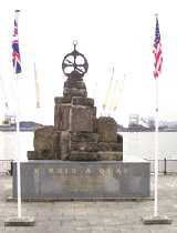 |
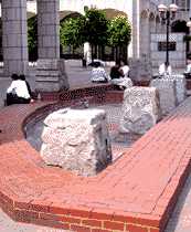
Virginia Settlers Monument.
|
On the banks of the Thames, reached by some steps leading off Jamestown Way. The quay was previously known as Brunswick Wharf. It was from here that the first successful English settlers embarked when they sailed to found Jamestown in Virginia. They were sent by the Virginia Company (similar to the East India Company) and received a charter from King James I, authorizing the project. James town was named after the King and local streets in Leamouth now bear names connected with the colony. One of the group of settlers was John Smith who was saved by Pocahontas. The original monument was vandalised and this new monument was set up in 1999. It was made using stones from the old quay capped by a sculptured astrolabe, then used by navigators for fixing their position. The 400th anniversary of the departure of the Virginia settlers will be celebrated in 2007. Virginia got its name when there was an abortive attempt at settlement in the reign of Queen Elizabeth I. (See No. 28. on the MAP )
Sculptor of the Mariner's Astrolabe: Wendy Taylor. For other works by the same artist see "Docklands Enterprise", "Knowledge ", "Rope Circle",
"Timepiece", and "Voyage 2001."
Virginia Settlers Memorial
|
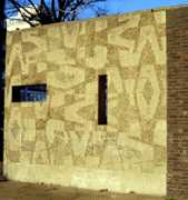 |
Decorative Wall. |
Cordelia Road. This is a concrete wall and the patterning has been achieved by making a contrast between the smooth and rough surfaced areas. This is one of a number of similar works by the same artist, which are in the entrance halls of the neighbouring blocks of flats. This is the only one in open public view. (See No. 29. on the MAP )
Sculptor: William Mitchell. Date 1959-62.
|
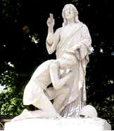 |
War Memorial. |
Opposite 162 St Leonards Road. This is an unusual design for such memorial, as it shows Jesus placing a wreath on the head of a kneeling male figure dressed in a short tunic. (See No. 30. on the MAP )
|
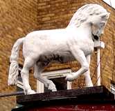 |
The White Horse. |
Poplar High Street. This was the sign which stood an old Pub called The White Horse. In the mid 1700s this was run by a couple called Howes. After several years as landlord, it was revealed that Mr Howes was in fact a woman. Her real name was Mary East. The women began by running a pub in Epping, where one night "Mr Howes" had his hand cut off in fight in the pub. The couple then moved to the White Horse. This is not the only case of an East End woman masquerading as a man. See the origin of the name of Hessel Street (For the White Horse see No. 31. on the MAP )
|
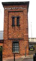 |
Water Into Wine. |
Southeast of the roundabout below Blackwell DLR station. This is just off Prestons Road. This is evidence of a modern miracle. The building originally was filled with water as it was an accumulator to provide hydraulic power for the docks in the area. Now the water has been turned into wine and the tower is called the Majestic Wine Warehouse. (See No. 32. on the MAP )
|
 TO READ NAME ~ CLICK FOR PHOTO & EXPLANATION.